San Bernardino Peak Trail is best done July through October

Despite wildfire destroying most of the trail’s trees, great views remain.
Day hikers can enjoy fantastic views in an area nicely recovering from a recent wildfire.
The 16–mile round trip San Bernardino Peak Trail (1W07) gains 4600 feet as it heads to a summit often mistaken for Mount San Gorgonio. Located in the San Bernardino National Forest, trailhead parking requires an Adventure Pass. Permits also are required, even for a day hike, with group size limited to 12. The good news is permits are free and can be easily obtained online from the San Gorgonio Wilderness Association at www.sgwa.org/permits.
This is a long hike, so get there early otherwise you’ll find a hot sun beating down on you for long sections of the trail. The trail is best done July through October; expect to find snow on it the other times of the year.
To reach the trailhead from the Coachella Valley, take Interstate 10 west through the Banning Pass. In Yucaipa, exit onto Oak Glen Road and take it right/northeast. Next, turn left/north onto Bryant Street, then right/northeast onto Calif. Hwy. 38. This takes you into the mountains. Once in Angelus Oaks, go right/east onto Fir Street then make a quick left/north onto Frontage Road, driving past the Angelus Oaks Fire Station. Then go right onto Upper Road/1N53; when the street splits, go right/south onto 1N53. Drive it to a small dirt parking lot at the trailhead.
From the trailhead, it’s uphill all the way, though the ascent is gradual at first. That changes with a series of switchbacks, constructed by the CCC during the 1930s.
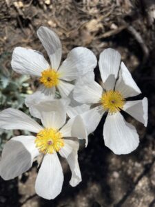
Flatbud prickly poppies cover large swaths of the trail, which was destroyed in the 2020 El Dorado Fire.
The 2020 El Dorado Fire ravaged sections of the trail. A forest is coming back, however, and in 2022 the trail was one of the best spots to enjoy the California Superbloom. What used to be a forest of black oaks, manzanita and pine is now covered in lilac–colored penstemon and golden wallflowers for the first mile then white-petaled flatbud prickly poppies for the next three to four miles. Most of these bloom in late June through July.
As the chapparal recovers, however, the wildflowers will disappear.
While wildfire may have destroyed the trees, it didn’t take away the vistas. As ascending, you’ll enjoy great views of the valley to the northwest with the Big Bear region beyond it. Once the trail bends, the urbanized Inland Empire area spreads below.
The peak – your destination – soon will come into sight. You’re almost halfway there.
At about 3.25 miles, the trail reaches Manzanita Flats. This is a good spot to rest, or if you’re just looking for a day hike, to turn back for a 6.5–mile round trip.
Despite wildfire destroying most of the trail’s trees, great views remain.
Or you can keep going. You’ll cross the flats. There is no shade in this section.
At 4.1 miles and just below 8300 feet, you’ll come to a trail junction; to the south is Columbine Springs and to the north is the Forsee Basin and John’s Meadow. Follow the trail east to the Limber Pines Campground.
The campground is at about 9318 feet. If you prefer to turn this into an overnight backpacking trip, this is a good spot to stay as there’s a spring that usually runs here.
Continuing from the campground, the trail ascends once again. There are more switchbacks, and then you’ll cross a small stream. Don’t drink from it, however, unless you filter it.
There’s also a cool bench – a slab of rock atop two other stones – that overlooks the valley below with Mill Creek running through it. Mount San Jacinto also can be seen on the horizon.

The Henry Washington Survey Marker is a historical point dating to 1852.
At 7.3 miles and about 10,270 feet, a short spur runs south to the Henry Washington Survey Marker. Erected in 1852, it’s a survey point that was used to lay out much of Southern California’s development.
Turn southeast into a spur at 7.9 miles to the summit.
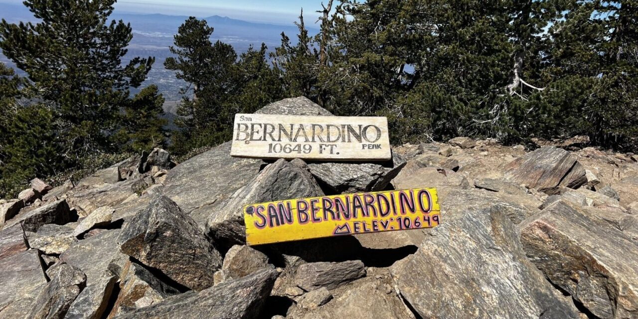
At 8 miles, you’re at the top of San Bernardino Peak and 10,649 feet above sea level. Trees cover part of the peak, so the views aren’t always great as they are on other parts of the trail. Still, you should be able to see Mount San Gorgonio looming another 84 stories higher to the east. Mount San Jacinto is to the southeast, Beaumont and Banning are in the valley to the south, Mount Baldy is to the northwest, and Big Bear Lake is to the north.
A pioneer friar, Francisco Dumetz, named the peak in 1835 for the 15th century Italian priest who worked to revive Catholicism in his homeland. By modern standards, though, Bernardo was no “saint”; his preaching condemned Jews, homosexuals, and Romani gypsies, and he led several book burnings.

San Bernardino Peak Trail map
Once you’ve taken in the views and rested, retrace your steps back to your vehicle, which is about 8 miles away.
Bring plenty of water and snacks if not a picnic lunch. Leashed dogs are allowed.
Image Sources
- 02-Despite-wildfire-destroying-most-of-the-trails-trees-great-views-remain.: Rob Bignell
- : Rob Bignell
- 03-The-Henry-Washington-Survey-Marker-is-a-historical-point-dating-to-1852.: Rob Bignell
- San Bernardino Peak summits at 10,649 feet above sea level.: Rob Bignell