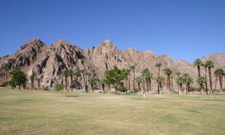
Day hikers can discover several desert wash plants on their way to a pyramid-shape monolith in the Mecca Hills.
The Pyramid Canyon Trail runs 6.04 miles with an elevation gain of 600 feet in the Mecca Hills Wilderness. The canyon cuts through the heart of the 26,242-acre badlands.
To reach the trail-head, take Calif. Hwy. 111 to Mecca. Turn left/northeast onto Fourth Street then at the roundabout go right/southeast onto Hammond Road. After a couple of blocks, head left/east onto 66th Avenue. As the street curves northeast, it naturally becomes Box Canyon Road. Cross the canal and drive about 2 miles. When the road curves southeast, look for two washes on the road’s left/right side. Park off the road at the second of the two washes.
Entering the wash, the trail splits into two canyons. Go right/northeast into Pyramid Canyon.
Initially, the sandy washes are quite wide. While the badlands is extremely dry, several large desert plants make their home in this wash.

Among the many plants calling the wash home is ironwood.
Among the largest is the desert ironwood. In ideal conditions it reaches a height of 33 feet with a trunk diameter of 24 inches. Most of the ironwood here is young, with its smooth, shiny gray bark a giveaway of its immaturity; older trees sport broken open bark.
The ironwood is a nurse plant with some 230 species of desert plants starting their growth in its protective shade. More than 60 reptiles and another 60 mammals rely on the ironwood for cover, nesting and food. If its seeds – which taste like peanuts – have fallen from the tree, you may spot doves and quail eating them.

Paloverde, also present in the wash, sports photosynthetic branches and twigs.
Paloverde can grow even taller than ironwood, topping out at 39 feet high. Its grayish green branches and twigs are photosynthetic, so it thrives even when it has no leaves, which usually pop out after a rainfall. The bush grows in washes and bajadas where it can collect the most water.

Smoketrees from a distance look like puffs of smoke in the wash.
The smoketree is slightly smaller at 25 feet high and across. It likes the desert’s direct sunlight, and since it needs a regular source of water, washes are a perfect home. As with paloverde, the smoketree’s branches contain chlorophyll pigments, allowing photosynthesis to occur all year. Because of its silver branches, from a distance the shrub looks like rising smoke. During June-July, it boasts impressive blooms of bluish-violet flowers.

Ocotillo can be found in gentle slopes and ridge tops along the wash.
On gentler slopes and the ridgetops, ocotillo stand out. Though the large, spiny sticks look like cactus, the ocotillo is more closely related to blueberry and tea shrubs. The plant can reach a height of 33 feet. After a rainfall, ocotillo sprouts small leaves and during spring, summer, and sometimes fall will bloom with bright, crimson flowers.
At about 0.85 miles, a canyon wash meets another wash from the right. Go left/north.
Typical of a canyon, the wash gains elevation the deeper you go into it. This allows hikers to see a variety of different rock layers, many of which are different colors – beige, burnt sienna. green, mauve, rust and white. The best time to see the rock colors is early in the morning on clear sunny days when the light doesn’t wash them out.

A high point at the canyon’s end offers a great view of the Salton Sea.
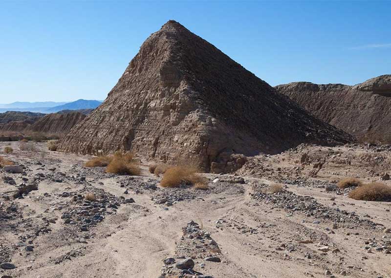
Around 1.8 miles, the trail reaches a small hill. After passing it, in about 50 yards look back. It appears to be a pyramid.
How did a pyramid get here? Ancient Egyptian travelers swept off course in a hurricane? Ancient aliens who also visited Mars?
Try simple erosion. Water and wind hitting at just the right angles over the centuries shaped it. Combined with our minds that often imagine familiar patterns in stone, and you get one of the more interesting rock formations in the Coachella Valley.
At about 2.27 miles, the wash splits. Go right/east. When the narrow canyon peters out, scramble to the ridge top for a great view of the Salton Sea.
The vista is from more than 120 stories up, as the ridge top is 1000+ feet above sea level while the sea’s surface sits at 236 feet below sea level. Covering more than 343 square miles, the blue water seems to stretch forever.
From the ridge top as looking at the sea, look for a small canyon/wash on the right heading west to southwest. Scramble down the canyon side and continue left/southwest on it.

Pyramid Canyon Trail topo map Plate 1
At 3.77 miles, you’ll arrive back at where the wash split. Continue straight-right/south. From there, retrace your steps back to your vehicle.
While shadows from the canyon walls can provide some shade at certain times of the day, for the most part the trail is entirely exposed to the sun. Given this, be sure to don sunglasses, sunscreen and sunhat, as well as bring plenty of water. Never hike this trail if rain is forecast or has fallen during the past 48 hours.

Pyramid Canyon Trail topo map Plate 2
Image Sources
- 02-Ironwood-Plants-800×568-1: Rob Bignell
- 03-Paloverde-Plant-800×568-1: Rob Bignell
- 04-Smoketrees-800×568-1: Rob Bignell
- 05-Ocotillo-800×568-1: Rob Bignell
- 06-High-Point-View-of-Salton-See-800×568-1: Rob Bignell
- 07-Pyramid-Canyon-Trail-Map-Plate-1-800×568-1: Rob Bignell
- 08-Pyramid-Canyon-Trail-map-Plate-2-800×568-1: Rob Bignell
- 01-Pyramid-Canyon-Trail-800×568-1: Rob Bignell