Given the length of the hike to Anderson Peak, you’ll want to start early in the day

The Forsee Creek Trail climbs the north side of the San Gorgonio range to Anderson Peak.
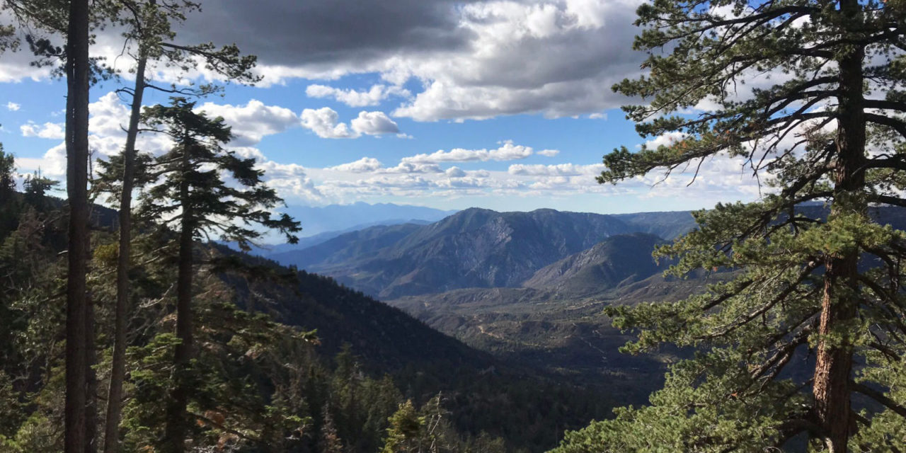
Coachella Valley hikers can stay cool with a hike up the north side of the San Gorgonio range on the Forsee Creek Trail.
The 13.6-miles round trip hike heads to Anderson Peak, which tops out at more than 10,000 feet above sea level. Given the hike’s length, you’ll want to start early in the day on it. It’s best done from late June through August, as there will be snow at the trail’s higher elevations in late May.
The north side of the range is a little longer of a drive than most of the popular trails on the ridge’s south side but won’t be as busy.
To reach the trailhead, from the Coachella Valley take Interstate 10 west through the Banning Pass. In Yucaipa, exit onto Oak Glen Road and take it right/northeast. Next, turn left/north onto Bryant Street, then right/northeast onto Calif. Hwy. 38. This takes you into the mountains. Well past Angelus Oaks, turn right/southeast. About a quarter mile from Hwy. 38 is a signed dirt road on the right. Take it to a small parking lot at the trailhead.
The trail starts at about 6515 feet elevation. It appears as “1E06.1” on some maps.

The 2020 El Dorado Fires ravaged part of the trail, but flora already is coming back.
Much of the trail’s lower half suffered greatly during the 2020 El Dorado Fires, leaving burned out trunks and charred soil in its wake. With destruction, though, comes renewal, and the flora already is returning.
At 0.1 miles, the route junctions a trail from the right/west. Continue left.
Watch the sand below for paw prints of the wildlife residing on the mountain. Among the prints you’re likely to see are those for coyote, mule deer, rabbits, and even brown bear. The thinner vegetation in burned out areas can make spotting mule deer easier.
You’ll reach spur trails at 0.4 then again at 0.6 miles. Shortly after that, a connector trail leads to a campground area.
A variety of songbirds that don’t make their way to the desert floor also can be seen along the way. Mountain bluebird and mountain chickadees are among them. A number of finches, which feed on seeds in pinecones, also inhabit this section of the San Bernardino Mountains.
At 0.8 miles, the route junctions with the John Meadow Trail (1E16), which comes in from the left/west. You’re at about 7000 feet elevation.
Around 7185 feet, the trail veers west. It soon crosses Cienega Creek. By mid-July, most of the creeks on the mountain side are dry, so always bring your own water.
At 7842 feet, the trail veers south then curls east again. You’ll cross Stetson Creek around 8071 feet. The route then curves west and recrosses the stream at 8268 feet elevation.

A variety of wildlife, especially mule deer, can be seen on the trail.
Beware of altitude sickness this high up. Since air pressure is lower at higher elevations, you will inhale less oxygen at the high elevation. To avoid altitude sickness, go at a slow pace that allows time for acclimatization.
Signs of altitude sickness include shortness of breath, dehydration, headache, nausea and dizziness. If you become confused, clumsy, vomit, and have a dry cough, the condition is serious.
Treating altitude sickness requires descending to a lower elevation where there’s more oxygen. In addition, drink extra water to avoid dehydration, and eat light, high-carbohydrate meals. If the condition is serious, get medical attention immediately.
In addition to a little harder breathing, you’ll also notice the temps dropping off. During summer, the top of the trail can be 20-25 degrees cooler than the Coachella Valley floor.
The trail recrosses Cienaga Creek at 8596 feet. A spur heads out on the right/west at 9270 feet.
Four miles from trailhead at 9482 feet is the spur to Jackstraw Campground. It’s 0.2 miles one way.
Around 10,220 feet, the trail starts to parallel its namesake, Forsee Creek. It’s below you on the right/west.

Sunsets are gorgeous on parts of the trail, making camping for the night worth carrying the extra gear. C
The route passes Trail Fork Springs Camp at 5.9 miles. Excellent views of the sunset can be had from the camp and is worth an overnight stay.
At 10,401 feet, the trail splits; go left/east onto Trail 1E66. You’ll soon enter Anderson Flat at 10,598 feet.
The Forsee Creek Trail junctions the San Bernardino Peak Divide Trail (1W07) in the flat. Go right/southwest onto it.
The route to the peak branches off the divide trail at about 10,630 feet. Head left/southwest onto the spur.
Anderson Peak tops out at 10,840 feet. It’s the fifth highest peak in Southern California outside of the Sierra Nevada.
Thanks to the heavy forestation – you’re not yet above the tree line, views aren’t as great on Anderson Peak as on other nearby summits. Still, you can spot the Yucaipa Ridge and Big Bear Lake.
After taking in the views and cool air, retrace your steps back to the parking lot.
Image Sources
- Great views: Rob Bignell


![Enrolling Now, Rewarding Careers Ahead [Sponsored]](https://ukenreport.com/wp-content/uploads/2024/04/COD_heroes_1-1385-2-440x264.jpg)