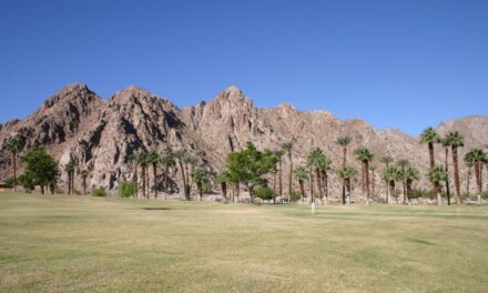
Bump and Grind Trail vista awaits 110 stories above Palm Desert and Rancho Mirage
Great views – and an invigorating workout – await on the Bump and Grind Trail in the Palm Desert-Rancho Mirage area.
A 4-mile loop and spur, the route actually combines three trails – the Mike Schuler, the Hopalong Cassidy, and the Mirage. It’s located in the Santa Rosa and San Jacinto Mountains National Monument.
To reach the trail-head, from Calif. Hwy. 111 in Palm Desert, turn west onto Fred Waring Drive. Go left/south onto Painters Path. The trail-head is in about 100 yards on the right/west. Park along the street. The trail-head is in Palm Desert, but most of the hike occurs in Rancho Mirage’s city limits.

The foothills along the Bump and Grind Trail glow with color at both sunrise and sunset.
At the trail-head, you can go one of two directions. Use the Mike Schuler Trail, which heads right/north and connects to the Bump and Grind. You’ll start gaining altitude quickly, as the trail is steep. The views of Palm Desert – and later of Rancho Mirage – are quite striking. Some hikers tackle the trail for a night hike to see the grid pattern of lights below.
After switch-backing up the side of a small foothill, the trail heads west along its rolling tip. This offers a nice view of the Santa Rosa Mountains to the south. The Little San Bernardino Mountains and the Indio Hills are to the north.
There isn’t much in the way of wildlife or interesting flora on this part of the trail. You will see a lot of people, though, as it’s a popular route.
From the hilltop, the trail steeply descends – it’s a mean 9 degree grade – and crosses three washes. From there, it heads up the side of a foothill.
At 0.8 miles, you arrive at the top. There, the Mike Schuler junctions with the Mirage Trail, which heads left/west, and the Desert Drive Trail, going right/east.
Heading onto the Mirage Trail, go left/west onto it. You’ll following a ridgeline that rises above the path you’ve walked so far. From this segment of the trail, you can catch a good view of the Porcupine Creek Golf Club in the cove to the right.
At 2 miles, the trail reaches a gate. A spur there leads to a summit, which is a half-mile away.
The trail to the summit passes through an important lambing area for peninsular bighorn sheep. Because of this, foot traffic to the summit is prohibited from Feb. 1-April 30. You still can hike the rest of the trail throughout the year. If you cut the trip to the summit, the hike becomes a 3-mile loop.

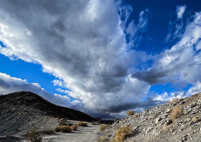
Part of the Bump and Grind Trail closes during spring to help protect bighorn sheep.
About 950 bighorn sheep live in the mountains surrounding the Coachella Valley. They blend in quite well with the tawny landscape, but their size gives them away when they move. Adult rams can weigh between 150-200 pounds – as much as a full-grown man – and ewes usually are 100-125 pounds. The adult ram’s horns sometimes reach 30 inches each in length and at the base are 15 inches in circumference.
Bighorn often can be seen feeding on acacia, encelia, krameria and sweetbush, but they will adapt their diet to what’s available. Indeed, father south in the Coachella Valley, some bighorn have migrated onto golf courses where they browse on the greens and drink from water hazards.

The summit on the Bump and Grind Trail offers great views of Palm Desert.
The summit sits at 1,280 feet, a full 110 stories about Palm Desert and Rancho Mirage. This affords great views of both Mount San Jacinto and Mount San Gorgonio – the latter the highest point in Southern California – to the northwest.
Going south form the gate, you’ll descend the ridge and the side of the foothills, ultimately reaching the Hopalong Cassidy Trail. Take a left onto it and head back to the trail-head and your vehicle. The last quarter mile can be moderately strenuous – even though you’re going downhill, maintaining your footing on such a steep slope requires some effort.

Bump and Grind Trail topo map.
While you can time the hike so you’re walking in the mountain range’s shadow, most of the day the trail is open to the sun. Be sure to wear sunscreen and don sunglasses and sunhat. Always carry plenty of water on this trail. If hiking at night, bring a flashlight.
Image Sources
- 02-The-foothills-along-the-Bump-and-Grind-Trail-glow-with-color-at-both-sunrise-and-sunset: Rob Bignell
- 03-Part-of-the-Bump-and-Grind-Trail: Rob Bignell
- 04-The-summit-on-the-Bump-and-Grind-Trail-offers-great-views-of-Palm-Desert: Rob Bignell
- 05-Bump-and-Grind-Trail-topo-map: Rob Bignell
- Bump-and-Grind-800×568-1: Rob Bignell