The largest palm oasis in North America awaits day hikers at Palm Springs’ Indian Canyons.

The Palm Canyon Trail heads through the largest palm oasis in North America.
The 2-mile round trip Palm Canyon Trail runs through the historic Agua Caliente Band of Cahuilla Indians tribal grounds. While the entire trail stretches for 16 miles, the oasis sits in canyon’s lower end and can be hiked on its own.
To reach the trailhead, in Palm Springs from Calif. Hwy. 111 go south onto South Palm Canyon Drive. In two miles, you’ll reach the Indian Canyons tollgate; there is a fee per adult and a lower rate per child. Shortly after the toll, the road splits; go right to the parking area next to the Trading Post. The trailhead is on the lot’s southeast side.
An exhibit of native dwellings sit near the oasis’ entry. Tawny, mostly barren, foothills rise above the canyon.
Stepping into the oasis, you’ll feel like you’re on the set of a Tarzan or Jurassic Park movie. Hundreds of California fan palms nestle around Palm Creek, where water runs in winter and spring.
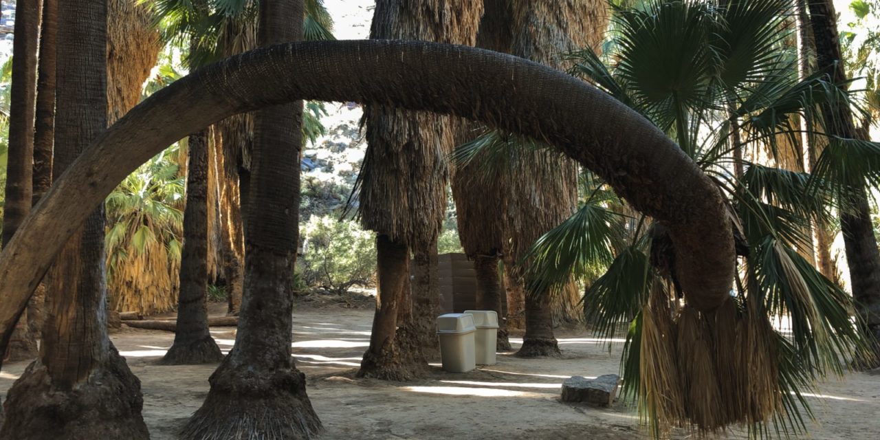
The largest of the fan palms towers 10 stories high and stretches three-feet wide. Some of the palms grow in fun, unique shapes, including one whose trunk has curled like an elephant trunk so its fronds can catch sunlight.
About a quarter mile into the canyon, you’ll come to a junction with a trail that heads southwest up the foothill. Remain in the oasis and continue roughly southeast.

Palm Creek, which runs for 16 miles, provides the lush poasis with ample water.
As walking along the creek, look at the boulders for rock mortars, which sometimes are bowl-like shapes and at other times round holes perfect for pegs. For more than 2000 years, the Cahuilla ground fruits, nuts and seeds on these rocks to use as ingredients in their food.
Several areas perfect for picnicking can be found along the stream, so consider bringing a basket lunch to replenish your energy.
In addition to fan palms, several other plants flourish in the oasis. Brittlebush, cottonwoods, globe mallow, lavender, various reeds, and sage all can be found there.

Interesting rock formations can be spotted in the oasis’ upper end.
Birds also thrive in the oasis, and you’ll even spot squirrels as well as a few harmless lizards. Given such abundant food sources, rattlesnakes have been spotted there as well, so don’t let any children with you wander.
As the trail reaches the end of the oasis, it curls north into the open desert. At that point, it becomes part of the Victor Loop Trail. You can follow the unshaded Victor Trail back to the parking lot, but for this outing, we’ll just focus on the oasis, so turn back here.
Alternately, the canyon and trail does head high into the San Jacinto Mountains, but it’s a long and arduous journey (16 miles one way) that requires several hours. For a description of a day hike you can take at the other end of the canyon, click here.
The hike is best done in October through April when temperatures are comfortable. Shade covers most of the trail, though there will be short periods in which the sun breaks through. Carry your own water rather than drink from the creek.
Indian Canyons opens at 8 a.m. and closes at night, so this is no spot for a dawn hike. A popular trail, it can be crowded on weekends. Informative tribal ranger tours are available Friday through Saturday. In the past, the canyon has closed for brief periods following storm damage, so check ahead.

Palm Canyon Trail topo map
Photo caption above: Some of the fan palms, as seeking sunlight, have grown in interesting ways.
Image Sources
- Rock formations: Rob Bignell
- Fan palms: Rob Bignell