Find the locations of some great Palm Springs-area desert oases
What would a desert be without an oasis? A patch of vibrant green amid unending sands, the sweet songs of birds rather than the howl of wind, the cool water pool that gives life amid the burning sun.
Palm Springs and the Coachella Valley have more than their share of these romanticized environs. Best of all, hiking trails lead to most of them.
California fan palms dominate most oases in and around the Coachella Valley. They usually occur along fault lines, where uplifted layers of rock bring underground water to the surface. As birds and other animals arrive at the water, they drop seeds that in the moist ground and air can thrive.
Here are some great Palm Springs-area oases to check out.
Indian Canyons
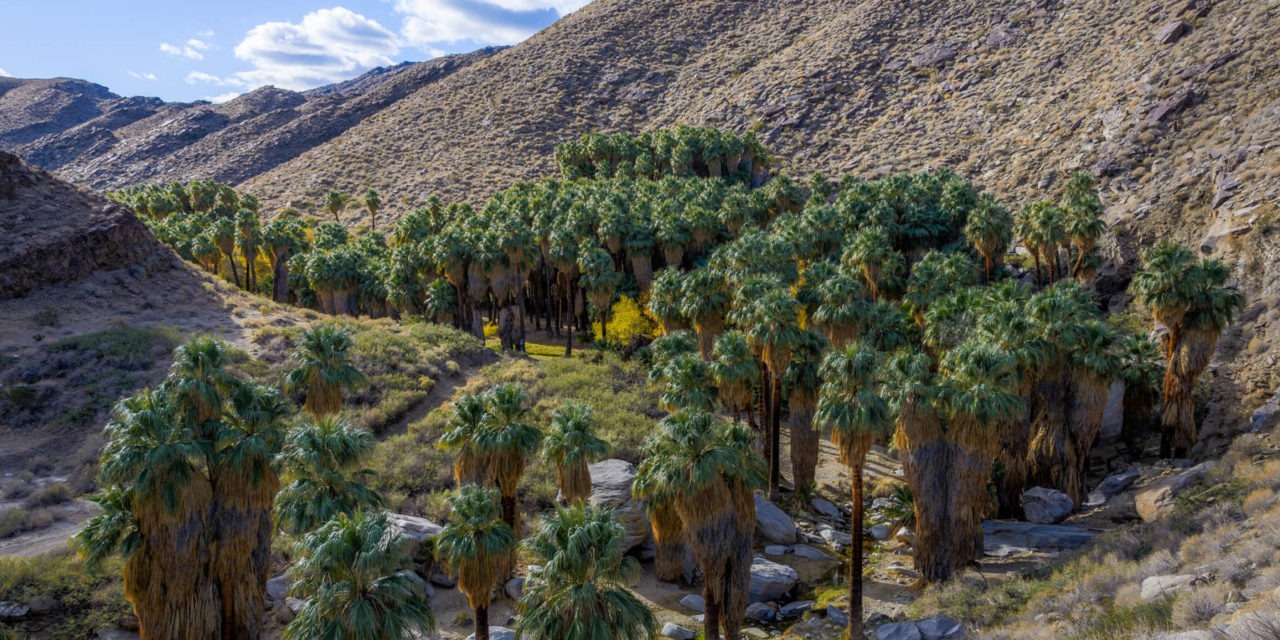
The largest palm oasis in North America awaits day hikers at Palm Springs’ Indian Canyons.
The 2-mile round trip Palm Canyon Trail runs through the historic Agua Caliente Band of Cahuilla Indians tribal grounds. While the entire trail stretches for 16 miles, the oasis sits in canyon’s lower end and can be hiked on its own.
To reach the trailhead, in Palm Springs from Calif. Hwy. 111 go south onto South Palm Canyon Drive. In two miles, you’ll reach the Indian Canyons tollgate; there is a fee per adult and a lower rate per child. Shortly after the toll, the road splits; go right to the parking area next to the Trading Post. The trailhead is on the lot’s southeast side.
Stepping into the oasis, you’ll feel like you’re on the set of a Tarzan or Jurassic Park movie. Hundreds of California fan palms nestle around Palm Creek, where water runs in winter and spring. The largest of the fan palms towers 10 stories high and stretches three-feet wide.
Andreas Canyon Trail
A lush desert oasis awaits day hikers on the Andreas Canyon Trail in Palm Springs’ Indian Canyons.
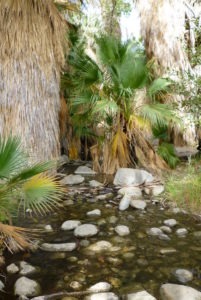
A mountain run-off stream supports more than 150 species of plants on the Andreas Canyon Trail.
The 2-mile round trip hike sits on the historic Agua Caliente Band of Cahuilla Indians tribal grounds. It’s a fairly flat trail, boasting a mere 50-foot elevation gain that children can handle and will enjoy.
To reach the trailhead, from Calif. Hwy. 111 go south onto South Palm Canyon Drive. In two miles, you’ll reach the Indian Canyons tollgate; there is a fee per adult and a lower rate per child. Shortly after the toll, the road splits; turn right and head to a gravel parking area. The trailhead is northeast of the lot.
The trail follows a year-round stream, fed by mountain runoff, with lush vegetation through a rocky canyon. Cascades with bubbling sounds sound downright refreshing in the desert. A number of birds live alongside the stream, and more than 150 plant species flourish in the oasis.
Murray Canyon Trail
Day hikers can head to a waterfall in the San Jacinto Mountains just outside of Palm Springs on the Murray Canyon Trail.
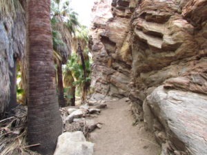
Sandy paths pass California fan palms in the canyon’s upper reaches on the Murray Canyon Trail.
The secluded walk to Seven Sister Falls is a 4.1-mile out-and-back. One of four canyons in the Agua Caliente Indian Canyons, this trail goes deeper and higher into the San Jacintos than the adjacent Andreas Canyon Trail. A great winter hike, it sports a 450-foot elevation gain.
To reach the trailhead, from downtown Palm Springs, take S. Palm Canyon Drive south to Indian Canyons. Once past the entrance station, when the road splits go right/southwest. The road dead ends at the Andreas Canyon Trailhead parking lot. From the lot, walk south into the oasis and veer left/east. The Murray Canyon Trail leaves from the oasis’ southeast side.
This verdant canyon boasts California fan palms, cottonwoods and desert willows, and this shaded canopy and the stream helps cool the desert temperatures. Grasses and flowers – California fuchsia, desert sunflowers, and desert lavender – fill the understory and open spots.
Santa Rosa-San Jacinto Mountains National Monument
Art Smith Trail
In addition to oases, hikers can enjoy panoramic views of the Coachella Valley and the opportunity to spot rare bighorn sheep on the Art Smith Trail.
The out-and-back trail runs 8.3 miles one way but can be shortened depending on your level of physical fitness. It’s best done September through May. Mornings offer cooler temperatures with the added bonus of blooming wildflowers if hiked after a rainfall.
To reach the trailhead, from Calif. Hwy. 111 in Palm Desert turn south onto Calif. Hwy. 74 (aka the Palms to Pine Highway). In about four miles, just past the Santa Rosa and San Jacinto National Monument Visitor Center entrance, turn right/west into the parking lot. You also can park in a smaller lot before reaching the visitor center entrance.
Unless backpacking, you’ll want to cut this trail short rather than do the entire length. A couple of good spots to turn around are at a palm oasis – there’s one at 2.5 miles in then another at about three miles, where the trail mostly levels out.
Coachella Valley Preserve
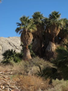
Spring water bubbling up along the fault feeds the Pushawalla Palms Oasis, reachable via the Pushawalla Palms Trail.
Day hikers can head to a desert oasis, with a good chance of spotting the endangered fringe-toed lizard, on the Pushawalla Palms Loop.
The trail runs 3.25-miles round trip through the Coachella Valley Preserve, which protects 17,000 acres in the Indio Hills. Several palm groves can be found in the preserve, including the well-known Thousand Palms Oasis.
To reach the trailhead, from Interstate 10 take the Ramon Road exit east through Thousand Palms. Once past town, turn left/north onto the aptly named Thousand Palms Canyon Road. In 1.5 miles, look for a dirt turnout off the road’s right/east side and park there. The sandy trail runs roughly southeast from the lot.
Indian Palms Trail
Two small oases await on the Indian Palms Trail. The 1.6-miles round-trip trail at the 17,000-acre preserve is open from 8 a.m. to 4 p.m. Wednesday through Sunday during October through May and from 6 a.m. to 8 p.m. June through September.
To reach the trailhead, take Interstate 10 to Thousand Palms and exit onto East Ramon Road. Go east on it. Next, turn left/north onto Thousand Palms Canyon Road. A parking lot is on the road’s left/southwest side; this serves the McCallum Trailhead with Indio Hills Palms and the Center for Natural Lands Management located there. Take the trail heading southeast toward the Pushawalla Palms Trailhead.
Mecca Hills Wilderness
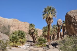
06 Hidden Springs is one of two oasis on the Hidden Springs Trail in the Mecca Hills Wilderness.
Day hikers can do a little spelunking as well as see two oases in the Coachella Valley via the Hidden Spring Trail.
The 5.1-mile round trip hike to The Grotto takes you through two oases and past several impressive painted rock canyons. Because of the desert heat, the trail is best done in October through May. Never enter the box canyons if rain is forecast or for a couple of days after rain has fallen.
To reach the trailhead, take Calif. Hwy. 111 south to Mecca. Turn left/northeast onto Fourth Street and at the roundabout go right/southeast onto Hammond Road. The street naturally curves east and becomes 66th Avenue.
East of town at Garfield Avenue, it becomes Box Canyon Road and curls northeast. The road then crosses the Coachella Canal and enters a broad sandy wash and finally Box Canyon.
Dos Palmas Preserve
San Andreas Trail
Day hikers can enjoy a massive desert oasis that hosts some of California’s rarest flora and fauna at the Dos Palmas Preserve.
The 0.9-mile San Andreas Trail weaves through an oasis and wetlands that sit atop an expansive alkali flats. Much of this lollipop trail is below sea level; in fact, the entire preserve at the base of the Orocopia Mountains averages 112 feet below sea level.
To reach the trailhead, take Calif. Hwy. 111 south of Mecca to along the Salton Sea. Once past North Shore, turn left/northeast onto Parkside Drive. Go right/southeast onto the dirt Power Line Road then turn left/east onto the dirt Dos Palmas Road (some maps show this as Sea Breeze Drive). In about 1.5 miles, you’ll reach a metal gate. The parking lot is on the right. At the lot, look for the “San Andreas Trail” sign and follow the sand path, bordered with rocks, toward the oasis.
Joshua Tree National Park
Sitting in the Mojave Desert, Joshua Tree National Park has six oases. Five of them can be reached by a trails:
- Cottonwood Spring Trail – This brief 0.2-mile round trip walk heads to a fan palm oasis with cottonwood trees. It’s a great spot to see many a variety of birds and on top of that, there’s shade! About 24 palms were planted here in the 1890s because of a once active spring. The trailhead is 1 mile east of the Cottonwood Visitor Center.
- 49 Palms Oasis Trail (https://ukenreport.com/fortynine-palms-oasis-trail-perfect-for-day-hike/) – To set up the oasis, the 3-mile round trip trail runs along a desolate ridge with barrel cactus seemingly your only company. Then it descend to a verdant fan palm oasis with water pools in a rocky canyon.
- Lost Palms Oasis Trail – This 7.2-mile round trip backcountry hike heads to a remote oasis in a shady canyon. Dike Springs is in a side canyon but requires some bouldering to reach. Park in the Cottonwood Spring lot.
- Oasis of Mara Trail – An easy 0.5 mile loop, the oasis has a long history of being used by Native Americans and wildlife. Leashed pets are allowed on the trail. The trailhead is at the Oasis Visitor Center.
- Victory Palms bushwhack – After taking in the Lost Palms Oasis, continue down canyon for a mile. Only a half-dozen palms stand in the oasis. It’s a 9.2-mile round trip backcountry hike that requires bouldering.
The sixth oasis, in Munsen Canyon, has no trail to it. An arduous cross-country 9-mile one-way hike up a wash and boulder-strewn canyon in the Eagles Mountains is required to reach it. in A two-mile stretch of the canyon are a set of eight small oases..
Image Sources
- 04-spring-water-bubbling-up-along-the-fault-feeds-the-pushawalla-palms-oasis-reachable-via-the-pushawalla-palms-trail.: Rob Bignell
- 06-hidden-springs-is-one-of-two-oasis-on-the-hidden-springs-trail-in-the-mecca-hills-wilderness.: Rob Bignell
- The Palm Canyon Trail heads through the largest palm oasis in North America at Indian Canyons.: Rob Bignell

