September marks a perfect time to hike San Jacinto Peak – clear sunny skies, comfortable temperatures and no snow.
While most hikers take the Palm Springs Aerial Tramway to below the summit, that’s not the only way to enjoy the Coachella Valley’s most famous mountain. The 5-miles round trip Devil’s Slide Trail lets you head up San Jacinto’s southwest face, offering spectacular views along the way.

Devil’s Slide Trail Topo Map
To reach the trailhead, from Palm Desert take Calif. Hwy 74 (the Pines to Palms Highway) into the mountains. At Mountain Center, turn right/north onto Calif. Hwy. 243. Once in Idyllwild, go right/northeast on Pine Crest Avenue. When the street curves east, it naturally becomes South Circle Drive. From South Circle Drive, turn left/north onto Fern Valley Road. The road ends at Humber Park; leave you vehicle in the parking spaces near the bathrooms on the park’s southeast corner, from which the trail leaves.

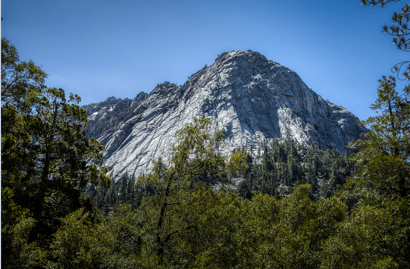
At around 7000-8000 feet above sea level, the Devils Slide Trail offers great vistas.
The trail starts at about 6280 ft. above sea level and immediately enters the San Jacinto Wilderness Area, which is within the San Bernardino National Forest. It passes through a largely evergreen forest with plenty of granite boulders along the way.
After a few switchbacks, the trail generally levels out for a little more than quarter mile. It then ascends again and upon passing below the dry Jolley Spring, turns level once more.
Towering above the trail at 10,824 feet into the sky – a full 1.95 miles above Palm Springs – is San Jacinto Peak summit. It’s the highest point in the San Jacinto Mountains and Riverside County, and the six highest in the lower 48.
The Cahuilla Indians called San Jacinto Peak I a kitch (or Aya Kaich), which translates to “smooth cliffs,” an appropriate name given that the mountain’s north escarpment at 10,000 feet is the most severe in all of North America. For the Cahuilla, this was the home of Dakush, their founder.
Euro-American settlers in the area began climbing San Jacinto Peak in the 1870s with the first recorded ascent in 1874. The Wheeler Survey followed in 1878 and officially named the mountain “San Jacinto Peak.”

The Devils Slide Trail heads up San Jacinto Peak’s southeast side. OWN
The best views from the trail are not of the Coachella Valley but to the west and south. Fern Valley and Idyllwild sit directly below the trail to the southwest while bald Tahquitz Rock/Lily Rock is to the southeast. Farther beyond, to the west is Hemet and the valley stretching from Riverside to Temecula. To the south are the mountains of the Cleveland National Forest; if you spot a shiny white dome in that range, it’s probably the Palomar Observatory.
The trail next crosses a tributary, fed by Powderbox Spring, to Strawberry Creek. At the next draw, the trail passes the creek’s headwaters at Middle Spring.
The trail then makes a broad switchback to an elevation about Middle Spring. It recrosses the first tributary and then switchbacks to Powderbox Spring.
In short order, the trail reaches Saddle Junction, having gained 1700 feet in elevation. From the junction, you can go a variety of directions – the Tahquitz Peak Lookout, the tram station, onto the Pacific Crest Trail, and even to San Jacinto’s peak. The latter is still several miles of walking away, and a much shorter way to reach it is via the tram station. Check it out here.
From the junction, retrace your steps back to the parking lot. Since you’re not going up the mountain face, you’ll get to enjoy those views on the way down.
The trail requires an Adventure Pass to park your vehicle and a wilderness pass to hike the trail. Only a limited number of wilderness passes are given out, so start early if hiking on weekends, holidays, or from Memorial Day to Labor Day. The wilderness permits are free, but the parking pass comes at a nominal fee; both can be picked up at the Idyllwild Ranger Station, which you’ll pass at the intersection of Hwy. 243 and Pine Crest Drive.
Image Sources
- Devil’s Slide Trail Topo Map: Rob Bignell
- Great Vistas: Rob Bignell
- The Devils Slide Trail heads up San Jacinto Peak’s southeast side.: Rob Bignell
- Devil’s Slide Trail: Rob Bignell