March – especially at month’s end – usually is peak bloom time on Mission Creek Trail

Clusters of creamy white flowers bloom on yucca along the Mission Creek Trail.
Among the Coachella Valley’s best spring flower hikes can be found just west of Desert Hot Springs.
The 8-mile round trip Mission Creek Trail sits between Desert Hot Springs and San Gorgonio Mountains in The Wildlands Conservancy’ Mission Creek Preserve. To avoid the summer heat, October to April mark the best times to hike the trail, but March – especially at month’s end – usually is peak bloom time.
To reach the trailhead, from Interstate 10 take Calif. Hwy. 62 north. In about five miles, turn left/west onto Mission Creek Road. A parking lot is at the road’s end.
Begin the hike by walking past the entrance gate. The trail runs alongside Mission Creek and gradually ascends; over the course of the next four miles, you’ll gain about 1300 feet.
When the West Fork Trail comes in from the left, continue straight-right/northwest.
At 1.5 miles, the trail reaches the Stone House. The structure and those nearby once were part of a dude ranch. Now a picnic area, it can be rented for day events.
The spring wildflower display around the stone house often is quite striking. Blooms are at their best if there was plenty of winter rain – and that certainly was the case this past winter in Southern California.

Brittlebush carpets the area around the stone house on the Mission Creek Trail.
Encilia, also known as brittlebush, carpets the ground and hill around the stone house. Its distinctive silver-gray leaves give the plant a soft, dreamy look. Growing from two to five feet high, this medium-sized rounded shrub’s branches are made of brittle wood and feature a fragrant resin that gives off a subtle aroma when the breeze blows against them. Brittlebush produces eye-catching yellow flowers with an orange-brown center.
The Mission Creek Trail proper starts west of the ranch house. You’ll follow a small streambed toward San Gorgonio Mountain, aka Old Grayback, Southern California’s highest point.
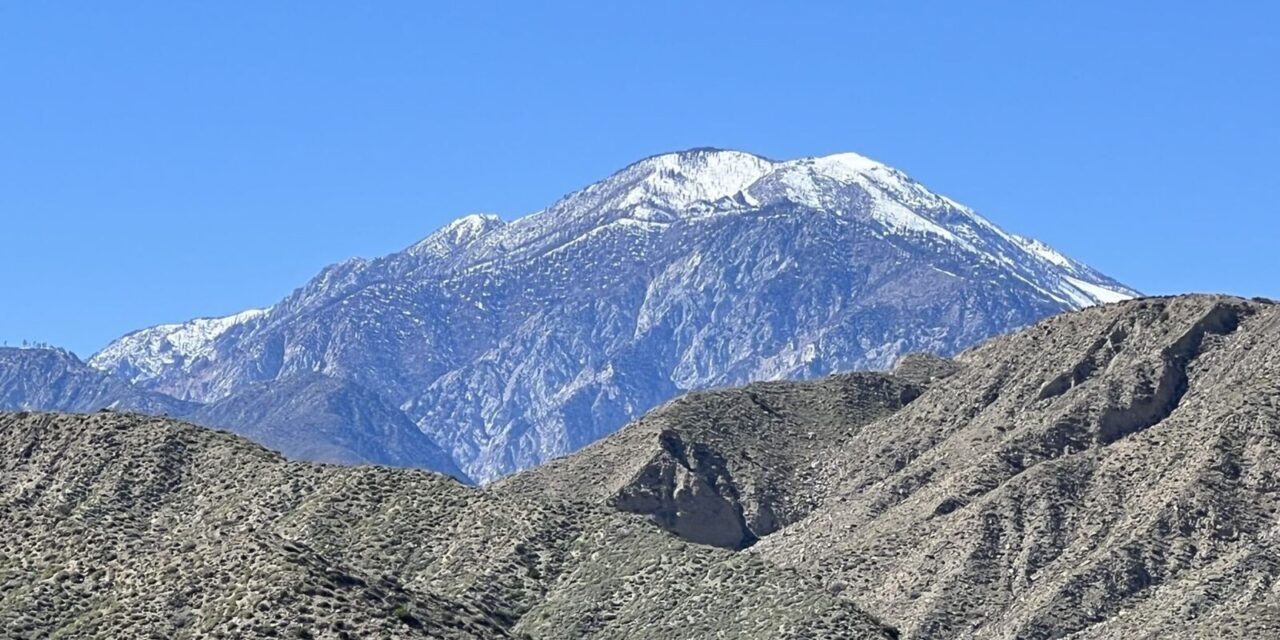
In short order, the trail enters a lush canyon. With great views of San Gorgonio Mountain to the west and Mount San Jacinto to the south, there are wildflowers aplenty here.
Among them is owl’s clover, a unique, beautiful wildflower that stands about a foot tall. Its hairy stems are covered in thin leaves, which are usually tipped with the same color as its flower cluster, giving it a distinct paintbrush look. The flower clusters range from pink-purple to lavender and truly resemble clover, although they are not related. Owl’s clover thrives in some of the driest places on Earth due to its deep taproot and protective bracts that reflect light, helping to conserve water.
Also present is bladderpod, an attractive and resilient plant, commonly found along roadsides and disturbed habitats throughout California. Its distinctive yellow flowers make a stunning contrast against the backdrop of its densely branching, dark green foliage and deep red stems. Sizable for a desert shrub, the bladderpod is capable of reaching up to two yards in height. Its three equal leaf-like leaflets are long, pointed ovals measuring up to 1.5 inches in length. When in full bloom, the abundant flower clusters at its stems’ ends offer a showy cluster of bright yellow flowers.

The beavertail cactus’s showy magenta flower usually can be seen on the Mission Creek Trail following rainfall.
Desert lavender is a captivating shrub renowned for its aromatic and pastel-hued flowers. It can be commonly spotted in the dry, arid regions of the American Southwest as well as northwestern Mexico in Sonora and Baja California. Desert lavender flourishes in sandy or gravelly soils boasting excellent drainage and full sun exposure with.
The bladder sage, also known as the paperbag bush, is a neat sight to behold when found in its native habitat of sandy and gravelly slopes and desert dry washes across the American Southwest. Its unique name comes from its distinctive small-bag or bladder-like shells that enclose its fruits. In the springtime, striking two-lipped flowers bloom. The upper lip is white to light violet while the lower lip is an intense dark violet with three lobes.
Of course, no Coachella Valley trail would be complete without cactus, and the beavertail takes up that job here. It grows on dry rocky slopes and yields a showy magenta flower. The blossom, which can be up to three inches wide, sits on the tip of the beavertail’s flat, broad stems. This cactus can grow in clusters up to six feet wide, so when flowering they form a striking swath across the desert terrain.
Mission Creek sits in a transition zone between the Mojave Desert to the north and the Colorado Desert of the Coachella Valley. Because of that, yucca can be found all along the trail. Actually, a small evergreen tree, the yucca’s bayonet-shaped leaves shoot out from a central rosette. The dead leaves droop and brown, forming a skirt around the yucca’s base. It can reach up to 16 feet high and five feet around. It yields several creamy white flowers.
About a mile stretch of the trail has mostly recovered from a fire that hit the area more than two decades ago.
There you’ll be able to see California bluebells. Also known as wild Canterbury bells, it is an iconic species of Californian deserts. These unique blossoms are quite remarkable – they produce great clusters of bell-shaped flowers that can reach up to 1.5 inches in length and show off a wide range of colors varying from lavender to deep blue-purple. They primarily form in chaparral or recently burned areas, reflecting its resiliency.
Flowers aren’t all you’ll see along the trail. Phainopeplas – a black-crested bird with red eyes – often can be spotted feeding on mesquite berries. Golden eagles usually fly over at dusk. Cooper’s hawk and kestrels also call the canyon home. If there’s water in Mission Creek, look for tree frogs poking their eyes above the surface. And there are plenty of harmless lizards darting around in the sand.
The trail reaches the Pacific Crest Trail in 4 miles, and this marks a good turnback point.
If you’ve got a lot of energy to burn off, though, you can continue on the PCT.
Going left/south takes you to the Whitewater River Canyon. The trail crests a low ridge then drops into Whitewater Canyon. There the Whitewater River flows off of San Gorgonio; it’s the only waterway that runs the length of the Coachella Valley to the Salton Sea, though concrete barriers guide most of it course in the valley’s urban areas.
The sandy river canyon heads uphill toward San Gorgonio, winding about boulders until reaching a reach a forest of willows and grasses. This extends the hike to about 12 miles with an additional 600 feet in elevation gain.
Alternately, you can continue straight/west toward San Gorgonio on the Mission Creek Trail.

Mission Creek topo map
Your goal is an overlook; it’s about three miles ahead and 1000 feet up, adding six miles to your hike. This part of the trail is best done after dawn when the sunlight plays with the colors in the surrounding mountain and desert.
About a mile past the PCT, the trail veers right and descends into a desert valley called Catclaw Flat. In two more miles, it ascends above the watershed to the west, offering great views from an overlook.
There’s no shade on the trail, so be sure to don sunhat, sunglasses and sunscreen, as well as bring plenty of water.
Image Sources
- 03-Clusters-of-creamy-white-flowers-bloom-on-yucca-along-the-Mission-Creek-Trail.: Rob Bignell
- : Rob Bignell
- In addition to wildflowers, hikers are treated to great views of Mount San Jacinto on the Mission Creek Trail.: Rob Bignell