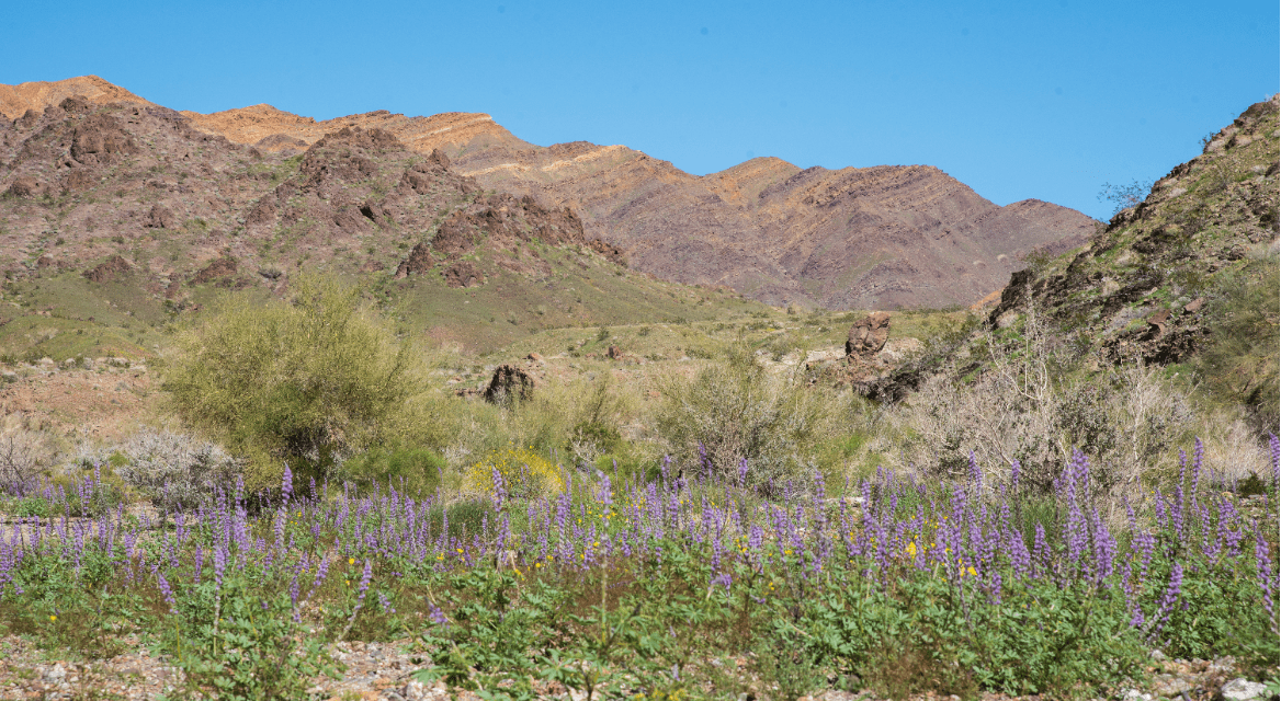
The Bradshaw Trail crosses a sandy and sometimes rocky wash south of the Orocopia Mountains.
Hikers can head across a segment of the first overland stage route connecting Arizona to the Coachella Valley.

The Bradshaw Trail crosses a sandy and sometimes rocky wash south of the Orocopia Mountains.
The Bradshaw Trail – also known as the Gold Road to La Paz – runs up to 70 miles from southeast of Indio to the Colorado River. An easy to reach segment goes 1.9-miles round trip east of the Coachella Canal.
To reach the trailhead, from Indio take Calif. Hwy. 111 east for 23 miles to the Salton Sea State Recreation Area park headquarters. Once there, turn left/northeast onto Parkside Road then left/north onto Desert Aire Road. At the Coachella Canal, go right/east onto Dos Palmas Spring Road/Coachella Canal Road. When the road splits, continue left/northeast on Coachella Canal Road. In about 4.75 miles, as the canal makes an almost 90 degree turn south, you’ll arrive at Siphon 24, which in some literature is referred to as Drop 24. This is a spot where the canal goes under the roadway. Park off the road.
The trail – listed as Summit Road on most maps – heads east into the Mojave Desert. The Orocopia Mountains are to the north and the Chocolate Mountains straight ahead.

A spur leads to a ridge at the base of the Orocopia Mountains.
Though the route crosses a wash coming from canyons in the Orocopia Mountains, the road is fairly clear of sand. The county even grades it sometimes. You won’t find any vehicles other than an occasional ATV out there. In short, it’s an easy walk with minimal elevation gain.
The trail’s origin dates to January 1862 when gold was found in La Paz (now Ehrenberg), Arizona. Seeing an economic opportunity, California Gold Rush veteran William Bradshaw decided a direct route linking La Paz to Los Angeles across 250 miles of desert was needed. That spring, Bradshaw and a party of eight men began scouting a route – a task made easy when Native Americans along the way provided them with a map showing a long-established Halchidoma Indian trade route.
The next year, Bradshaw established the overland stage route running from San Bernardino to La Paz. It became the first road to cross the Riverside County desert to Arizona. Miners and passengers regularly used it.
Among the stops Bradshaw set up was “Agua Caliente,” located almost where the modern Tahquitz Canyon Drive and Palm Canyon Drive intersect in downtown Palm Springs. This brought the first white settlers to what is now Palm Springs.
By the mid 1870s, though, all the La Paz gold had been picked over, and the road faded into history. The route as well as the Palm Springs station closed in 1877.
Thanks to route’s remoteness, the area near it became the Chocolate Mountains Aerial Gunnery Range. The Navy and Marine Corps still use it today. Because of this, do not stray south of the trail or you’ll be on the range. Should you see munitions off the trail, don’t foolishly touch them or there may not be enough of you for rescuers to bring back to a funeral home.

An expansive view of the Salton Sea awaits from a ridgeline on the Orocopia Mountains.
Keep track of your steps. At 0.96 miles, you’ll reach the gunnery range boundary where it briefly juts north of the trail. Turn back there.
If looking to extend the trail a bit, there is a 2.2-mile round trip jeep trail, with two spurs, branching north into the Orocopia. One of the spurs heads up the side of ridgeline and offers fantastic views of the Salton Sea to the south.
There’s not an iota of shade on the trail, so be sure to don sunscreen, sunglasses and sunhat as well as bring plenty of water. Never hike the trail in summer. Be forewarned that cell phones may not work on parts of the trail. Dogs are allowed.
Image Sources
- Trail explodes with color: Rob Bignell