Seven Pines Trail passes seven of California’s iconic conifers
When temperatures soar on the Southern California desert floor, the best place for hikers to get some relief is the mountains – especially fresh scented, pine-covered slopes.

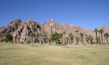
The Seven Pines Trail heads up Mount San Jacinto’s west slope with the Coachella Valley on the other side.
One excellent hike that fits the bill is the 6.8-miles round trip Seven Pines Trail near Idyllwild. The forested trail follows the North Fork of the San Jacinto River to its headwater at Deer Springs. Because of its elevation, the best time to hike the trail is June to October – not just because the weather is more pleasant than on the desert floor but because the access road to it usually closes November through May.
A Wilderness Permit is required to hike the trail. You can pick one up at a self-serve kiosk at the Ranger Station in Idyllwild or at a kiosk on Stone Creek campground off of Azalea Trails Road.
To reach the trailhead, from Palm Desert take Calif. Hwy. 74 south. In Mountain Center, turn right/north onto Calif. Hwy. 243, Drive through Idyllwild. Just before reaching the Alandale Ranger Station, go right/north onto Azalea Trails Road/Forest Route 4S02. You’ll pass the Stone Creek Campground. After the Azalea Trails Girl Scout Camp, watch for the trailhead on the right/north; be forewarned that it’s not well-marked. Park off the side of the road.

Seven Pines topo map
The trail begins at an elevation of 6320 feet, more than a mile above the sea level. You’re on the west slope of Mount San Jacinto.
Seven Pines Trail is so named because of the seven conifers (not all of which actually are pines) that can be seen either alongside the trail or in the distance. They include white fir, incense cedar, sugar pine, Coulter pine, ponderosa pine, Jeffrey pine, and lodgepole pine. You’ll feel like you’re walking through the Sierra Nevada or far northern California, where those trees dominate.
Five of the seven conifers can be seen at the trailhead.

White fir is one of seven major California conifers that can be seen on the Seven Pines Trail.
White fir ranges between 80-195 feet tall with a trunk diameter of up to 8.9 feet in diameter. They live up to 300 years. Their low limbs drip water that their roots then can collect as moisture. Those branches offer an excellent escape for small birds fleeing predators. They also allow flames during wildfires to climb up into the canopy; in the Sierra Nevada, that poses a great danger to sequoia groves, and so some have called for the removal of white fir there.
The large and fragrant incense cedar can grow between 130-195 feet high with a 3.9 foot-diameter. Smooth, orange-brown bark of younger incense cedars turn heavily fissured and gray as the tree ages. Native Americans used the tree for a variety of purposes, such as making baskets and hunting bows, curing illnesses, and as a tool to produce fire via friction.
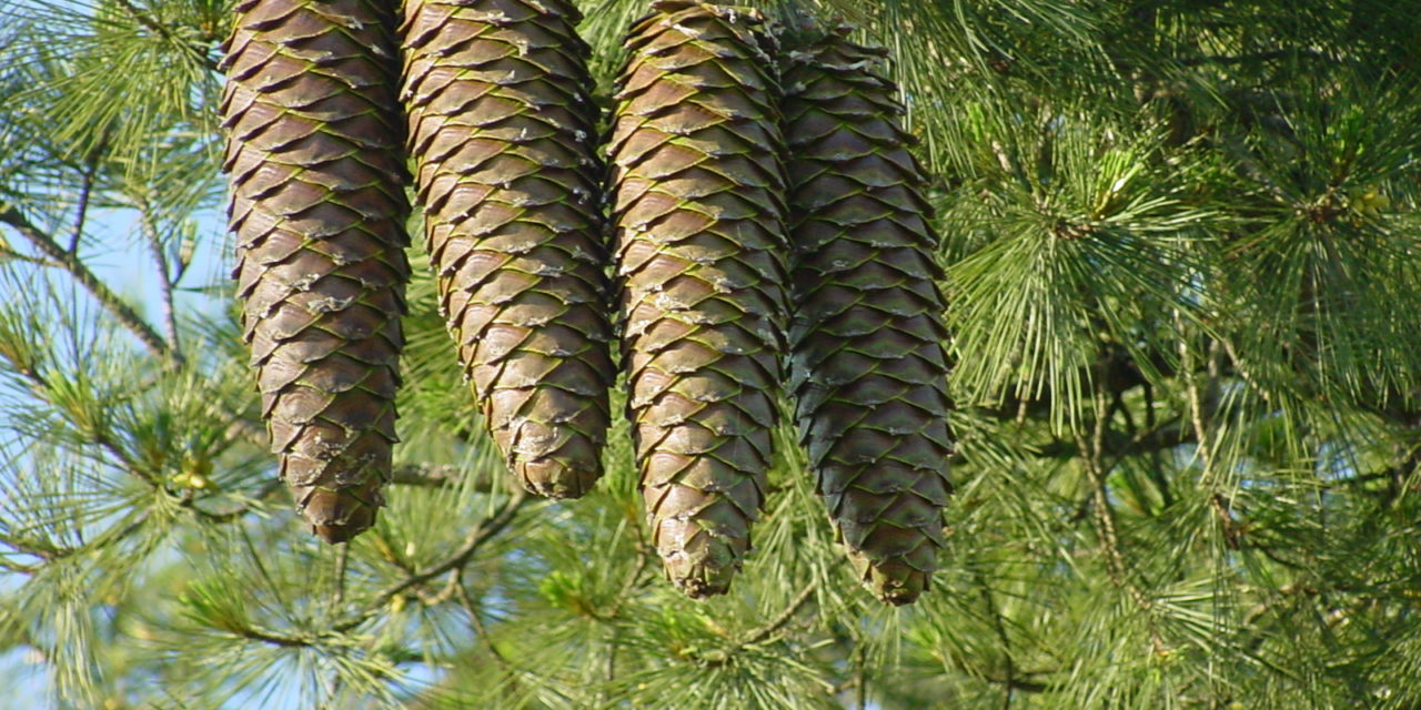
Sugar pine is the tallest and most massive of the pines. It rises as tall as incense cedar, but the trunk is far larger with a diameter of nearly five to just a little over 8 feet. Native Americans used its resin as a sweetener, and famous naturalist John Muir considered it better than maple syrup. The tree boasts the longest cones of any pine.
Coulter pine, however, lays claim to the heaviest of pine cones, with mature ones averaging 4.4-11 pounds. When it drops from a tree that reaches between 33-79 feet tall, it can pack quite a wallop. Because of that, the Coulter pine has earned the nickname “widowmaker,” and anyone working in a grove of them is well-advised to don a hardhat. Its trunk can reach a diameter of 3 feet, and the tree prefers south-facing slopes.

Young ponderosa pines have back to brown bark.
Ponderosa pine ranges from 40-223 feet tall with a trunk diameter of 7 feet wide. Younger trees have blackish-brown bark, so early loggers referred to them as “blackjacks.” Mature ponderosa pines, however, have yellow to orange-red bark in broad plates with black crevices between them. Sometimes the tree hybridizes with Jeffrey pines.
As expected in most Southern California forests, you’ll also find canyon live oak and California black oak mixed with the pines.
From the road, the trail ascends up a steep, rocky hill. The payoff is excellent views of Black Mountain and the range’s other northern peaks.
The pine’s seeds attracts a number of animals. Squirrels particularly like and will gather the Coulter pine’s seeds while yellow pine chipmunks and Steller’s jays hoard sugar pine seeds. The forest also provides plenty of foraging opportunities for mule deer.
Next the trail descends about 200 feet into the canyon for the North Fork of the San Jacinto River.

The resin of the Jeffrey Pine smells like butterscotch.
The sixth of the trail’s famed conifers – Jeffrey pine – appears in the canyon. It typically grows up to 82-131 feet tall, but is smaller when at or near the tree line. Its resin smells like butterscotch. The tree often is confused with the ponderosa pine, as both look quite similar. To tell the difference, look at the cones – the Jeffrey pine’s barbs point inward so that they feel smooth, but the ponderosa pine’s barbs stick outward so they are prickly in the hand.
From 0.81 to 0.85 miles, the trail makes several switchbacks up the slope. This set is the first of many along the way.
At 1.26 miles, the trail crosses a small side creek and then a mere football field later crosses the North Fork of San Jacinto River. The elevation here is 6880 feet. Along the way, you’ll officially enter the San Jacinto Wilderness.
Large boulders abound alongside the trail. One of the more dramatic rock formations is a knoll that rises to 8000 feet. It’s about a third of a mile south of the trail, and there’s a good view of it at 1.99 miles in.
The trail once again crosses the North Fork of San Jacinto River at 2.63 miles. Your elevation is about 8030 feet.
Next the trail reaches a meadow-like area at 2.9 miles. Here the last of the route’s seven conifers – the Sierra lodgepole pine – appears.
The tree can rise up to 118 feet with a diameter of 2 feet. Its scaly bark ranges from orange to purple-brown in color. Its seed cones take 14-18 months to mature. Some of the state’s best stands of Sierra lodgepole pine are found here and on the southern approaches to Mount San Jacinto’s peak. All the trees here are fairly old and so also extremely large.
As approaching your turnaround spot, the trail makes a third and final crossing of the North Fork.
Finally at 3.29 miles, the trail meets the Deer Springs Trail/Pacific Crest Trail, at an elevation of 8640 feet. The North Fork’s headwaters are at Deer Springs. While trails here can be taken to Mount San Jacinto’s peak, that requires several more hours, so for day hikers Deer Springs marks a good spot to turn back.
Be aware than 25 treefall hazards have been identified on the trail, according to surveys done in spring 2020. Because of this, you may need to go around trees, so be sure to bring a topo map and compass to ensure you don’t get lost.
No dogs are allowed in the wilderness area.
Image Sources
- Young ponderosa pines: Rob Bignell
- Sugar pine: Rob Bignell