South Lykken Trail winds across the side of Mount San Jacinto in Palm Springs

The South Lykken Trail offers several great views of Palm Springs below.
Great views of Palm Springs, neat rock formations, and an opportunity to see bighorn sheep await on the South Lykken Trail.
The 4.5 miles one-way trail traverses the side of Mount San Jacinto, gaining slightly more than a thousand feet of elevation along the way. Given this, arranging for a shuttle car at the other end of the trail is a good idea.
To reach the trailhead, from South Palm Canyon Drive south of downtown Palm Springs, take West Mesquite Avenue west. The road winds to a parking lot. If you’re not doing a shuttle car, park there. From the lot, walk the road past the Agua Caliente Tahquitz Visitor Center. If you left your vehicle at the lot, stop in the center and pay to use the nearby Tahquitz Canyon Trail, even though you’re not going on it; you’re really just paying for parking.

South Lykken Trail topo map
Look for a trail switchbacking up the mountainside and start up it. This is the southern half of the Carol Lykken Trail, which winds across 9.5 miles of mountainside ridges overlooking Palm Springs.
Rock outcroppings abound on the steep mountainside all along the trail. The mountain – as well the other peaks in the Santa Rosa and San Jacinto Mountains National Monument – began to form about 150 million years ago during the Jurassic when the North American tectonic plate began to ride over the Pacific plate. The buried plate, under great pressure and heat, turned to molten magma that slowly rose, mixing with and morphing the sedimentary layers above. This created the mahogany-colored rock seen today in the mountainsides from Palm Springs to Palm Desert.
About 50 million years ago, under continued tectonic pressure, the land crumpled and pushed up the mountains we see today from the Santa Ana Mountains near Riverside to the tip of Baja California a thousand miles away. Erosion has stripped away some of the sediment covering the rocks, exposing them. Many are bent at odd angles or form odd, interesting shapes.

A rock window is one of several interesting formations on the South Lykken Trail.
In addition to the cool rocks, the trail offers an impressive view of Palm Springs on the valley floor below. During spring and summer, the city’s lush greenery can be quite a contrast to the trail’s barrenness and the stark Little San Bernardino Mountains across the valley floor.
Upon cresting the ridgeline, a nice view of Tahquitz Canyon sits below to the west. You should be able to see the oasis and Tahquitz Falls.
The trail continues gaining elevation as heading south. Eventually it reaches 1536 feet, a full 101 stories above Palm Springs.
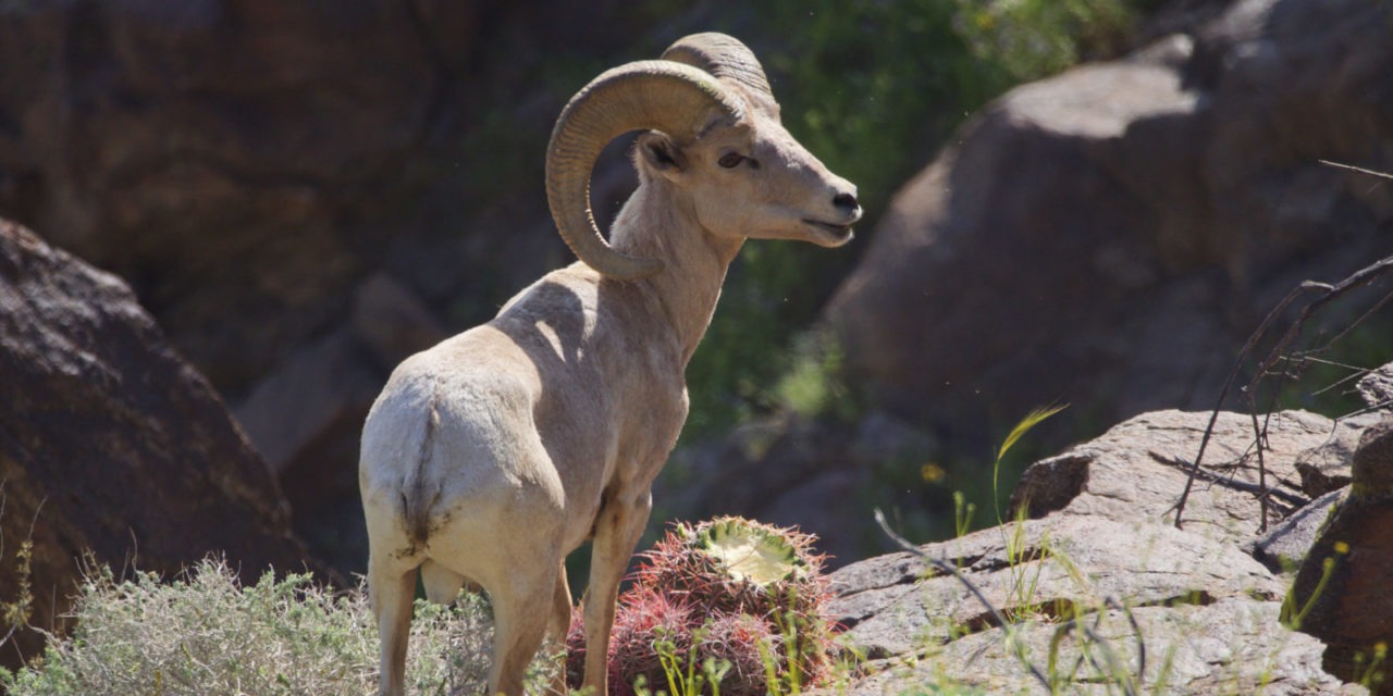
This is peninsular bighorn sheep country. While they aren’t always present, keep an eye out for them standing on the mountainside above you.
About 950 bighorn sheep live in the mountains surrounding the Coachella Valley. They blend in quite well with the tawny landscape, but their size gives them away when they move. Adult rams can weigh between 150-200 pounds – as much as a full-grown man – and ewes usually are 100-125 pounds. The adult ram’s horns sometimes reach 30 inches each in length and at the base are 15 inches in circumference.
Bighorn often can be seen feeding on acacia, encelia, krameria and sweetbush, but they will adapt their diet to what’s available. Indeed, father south in the Coachella Valley, some bighorn have migrated onto golf courses where they browse on the greens and drink from water hazards.

Tahquitz Canyon and its waterfall are visible from a ridgetop on South Lykken Trail.
While the trail and mountainside appears barren compared to the valley below, it can be verdant during March and April after snow melts and rainfalls. There’s plenty of creosote and cactus from barrel to prickly pear. During spring, you’ll likely see blooming yellow brittlebush and flowering cacti.
After reaching its zenith, the trail gradually descends toward then switchbacks into a draw. Next the trail rises up and down the mountainside, but on balance you’re gradually losing elevation.
One nice picnic and picture spot is the Simonetta Kennett viewpoint. It sits at around 1125 feet elevation.
From there, the trail drops steadily. It ends at South Palm Canyon Drive south of Murray Canyon Drive.
There’s absolutely no shade on the trail, so be sure to don sunscreen, sunglasses and sunhat as well as bring plenty of water. You’ll want to wear quality hooking boots given the rocky surface, and a trekking pole is highly recommended.
Dogs are prohibited on the trail, and tickets with fines are handed out to those who bring them.
Image Sources
- Bighorn sheep: Rob Bignell
![Healthy Desert, Healthy You [Sponsored]](https://ukenreport.com/wp-content/uploads/2026/07/2026-v2-Takaahi-Wada-Angelica-Geter-800x568-1-440x264.jpg)