The Bat Caves did not exist until a man-made accident created the Salton Sea
Day hikers can explore the only caves in the Salton Sea area at Bat Caves Buttes Trail.

Bat Caves Buttes Trail topo map
The 3-mile lollipop trail runs through the Salton Sea State Recreation Area. January is an excellent time to hike to the caves as daytime highs along the Salton Sea usually only hit the high 60s.
To reach the trailhead, from the Coachella Valley take Calif. Hwy. 111 south. After passing the Salt Creek Beach Campground, watch for Crooker Drive on the right/west. A cell tower stands next to the road. Park off of Crooker Road.

The Bat Caves Buttes Trail begins at a cell tower in the ghost town of Durmid.
The trail’s stem starts in a ghost town named Durmid, which sits at 197 feet below sea level. Nothing other than dirt roads remain there today, but during the 1950s through the early 1960s, this was a hoppin’ place. Developers marketed the Salton Sea as a resort destination, and vacation homes, hotels, yacht clubs and golf courses were built along its shores. A cafe used to sit where the cell tower now stands, and older guidebooks describing the trail often will tell you to park at the “abandoned cafe.”
To begin the hike, walk across Hwy. 111 and the railroad tracks. Straight ahead, you’ll see buttes rising from the desert floor. Those are the Bat Caves Buttes. There’s no marked trail; just head straight ahead across the sandy wash. Sometimes off-road vehicle tracks can be followed to the butte.
At one time, the entire area was a plateau as high as those buttes. Water erosion has washed away the landscape, but a hard caprock atop the Bat Caves Buttes have prevented them from entirely disappearing. Much of the erosion has occurred because the buttes sit just south of the San Andreas Fault, where uplift encourages the water to run southwest into what is now the sink forming the Salton Sea.
Seashells can be found along the ascending trail. This part of the world was at the bottom of an ancient sea about 3.1 million to 3.2 million years ago. At that time, the Gulf of California extended into the Coachella Valley with the warm shallow waters running about 30 to 98 feet deep. Fossils for at least four kinds of sharks and rays as well as three kinds of fish from that era have been found farther north in the valley.
Though fairly barren today, after a good rainfall the wash can brighten with greenery. Lilies often pop up in February amid the green-leaved desert scrub.

The Bat Caves Buttes appear barren but turn green after winter rains.
At 0.75 miles, you’ll reach the buttes’ base at exactly sea level. Go left/northwest around the buttes. You’ll spot footpaths cutting through and atop the rock formation. Follow the trails to the various caves in the butte.
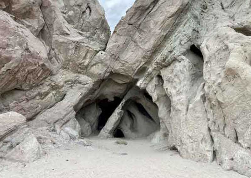
The caves didn’t exist until a man-made accident created the Salton Sea in 1905. That year, heavy snowmelt and rainfall caused the Colorado River to swell. The five-year-old Alamo Canal, which was heavy with silt, couldn’t handle the overflow and broke. For two years, water poured from the Colorado down the canal, two riverbeds, and two dry arroyos into the Salton Sink.
In what is often labeled as California’s greatest environmental disaster, more than 350 square miles of land was submerged under several feet of water.

Bird tracks cross the sand at the base of Bat Caves Buttes
The Bat Caves were created during the initial flooding with waves tunneling into the butte. As the water level dropped – the Salton Sea is evaporating and one day will disappear – the caves were exposed. Because of the limited time the waves had to drill into the buttes, most of the caves are shallow with the deepest one only about 90 feet long.
The caves do have bats, which are harmless to people. Avoid disturbing the bats, however, by going no further than the cave entrances.
At the buttes’ top is a park bench overlooking the Salton Sea and the Peninsular Ranges beyond. During January, the mountains usually are snow-capped.

A park bench atop the buttes offers a great vista of the Salton Sea.
Upon looping the buttes, go left/southwest on the stem back to your vehicle.
At times, irresponsible people leave their trash and write graffiti on the rocks. To ensure a positive experience for other hikers, always carry out what you carry in, and don’t vandalize the formation.
The trail is entirely open to the sun, so be sure to don sunscreen, sunglasses and sunhat. Also bring plenty of water, a minimum of three quarts per person. Leashed dogs are allowed on the trail.
Image Sources
- 06-Bat-Caves-Buttes-Trail-topo-map: Rob Bignell
- 01-The-Bat-Caves-Buttes-Trail-begins-at-a-cell-tower-in-the-ghost-town-of-Durmid_02: Rob Bignell
- 02-The-Bat-Caves-Buttes-appear-barren-but-turn-green-after-winter-rains._02: Rob Bignell
- 03-Bird-tracks-cross-the-sand-at-the-base-of-Bat-Caves-Buttes._01: Rob Bignell
- 05-A-park-bench-atop-the-buttes-offers-a-great-vista-of-the-Salton-Sea._02: Rob Bignell
- Buttes-Trail-Feature-Image-800×568-1: Rob Bignell