Marion Mountain tops out at 10,362 feet.

The trail heads along Marion Ridge and offers great views of Indian Mountain.
Coachella Valley hikers can stay cool on a heavily forested trail that many use to reach Mount San Jacinto.
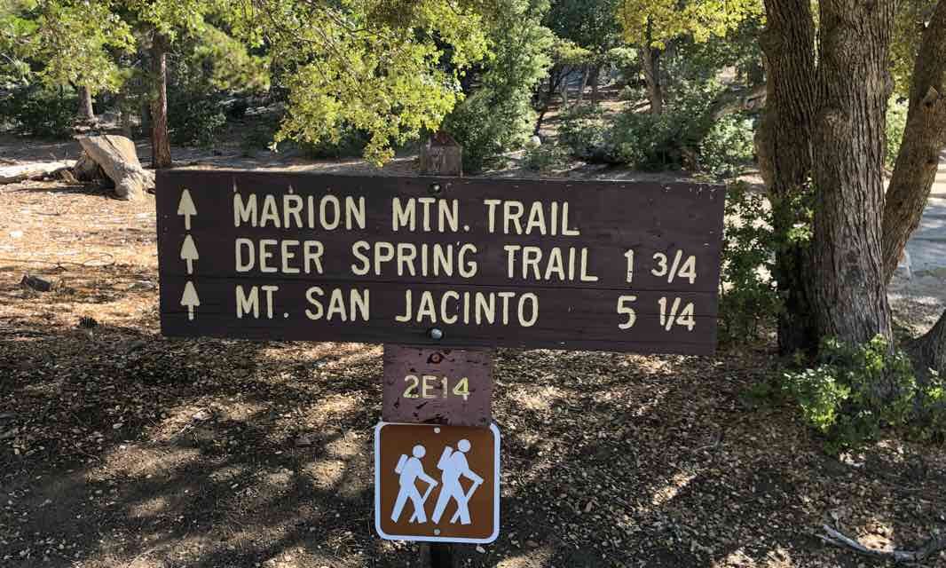
The 4.8-mile round trip Marion Mountain Trail (aka Trail 2E14) sits near Idyllwild in the San Bernadino National Forest. It sports a 2300-foot elevation gain so will be a workout.
But temperatures will be a full 30 to 40 degrees cooler on the trail then in the Coachella Valley. If you start early enough in the morning, temps in the forest will be in the mid-60s.
To reach the trailhead, from Palm Desert, take Calif. Hwy. 74 south into the mountains. Turn right/northwest onto Calif. Hwy. 243. About five miles out of Idyllwild, turn right/east onto Marion Mountain Road. When the road splits, go right/northeast toward the Marion Mountain Campground. Car parking is available just before the campground. The trailhead is at 6,480 ft. above sea level.
Heading roughly east, the trail at 0.35 miles crosses a road near the campground. A path to the campground then junctions the main trail at 0.45 miles; continue right/east.
Next the trail junctions a dirt jeep trail at 0.5 miles. This road usually is shown as the Stone Creek Trail on maps; going south on it heads to Sawmill Flats. Ignore the road and keep heading straight/east.
The steep trail heads up the northwest flank of Marion Ridge. Far-reaching vistas from the ridge can be enjoyed to the west, east and south. Most notably to the west is Indian Mountain, a shorter summit in the San Jacinto Range, and the valley beyond it. To the northeast, you can catch views of Fuller Ridge, which runs from the north side of Mount San Jacinto toward Banning.
Mount San Jacinto to the north-northwest – its peak is just 1.3 miles away – and Jean Peak to the northwest – its summit is just 0.8 miles away – block much of the northern view, however.

Sugar pine can be found in abundance along the trail.
Picturesque boulder piles sit between sugar and Jeffrey pines along the trail. If you start smelling butterscotch, your hiking companion probably hasn’t broken open a pudding, but a grove of Jeffrey pines is nearby; the tree’s bark smalls a lot like the sweet dessert.
A variety of wildflowers bloom during summer along the single-track trail. Among them are Indian paintbrush, lupine, shooting star, and western columbine.
At about 1.6 miles, the trail enters the San Jacinto State Park Wilderness.
The trail soon flattens out a bit. You’ll know your close to the turnback point when you pass a meadow on the right/south.
At 2.4 miles, the trail reaches the turnback point at 8775 feet elevation – the junction with the Pacific Crest Trail. Going left-straight/east on it takes you to Fuller Ridge to the northwest; going south heads along the Desert Divide separating the Coachella and Garner valleys.
You can continue to San Jacinto Peak, which is another 3.1 miles away, by going north on the PCT. The Marion Mountain Trail combined with the PCT is the shortest route to that summit.

The trail offers good views of the Fuller Ridge to the northwest.
Unfortunately, you can’t reach the peak of Marion Mountain, which is the looming high point southeast of the turnback point. Marion Mountain tops out at 10,362 feet.
Marion Mountain got its name thanks to unrequited love. During the late 1800s, Marion Perkins – who worked for the Indian Bureau on the Morongo Valley Reservation – was in love with a U.S. Geological Survey topographer named Edmund Taylor Perkins. Perkins, however, was in love with Jean Waters, who he met while in northern California. He named one peak after Marion and the nearby (and slightly higher) Jean Peak after Miss Waters.
Perkins eventually married Jean Waters – the taller of the two peaks who were rivals for his affection.
Image Sources
- The Marion Mountain Trail starts north of Idyllwild near a national forest campground.: Rob Bignell