On the Desert Divide, the loop offers an excellent view of Palm Springs.
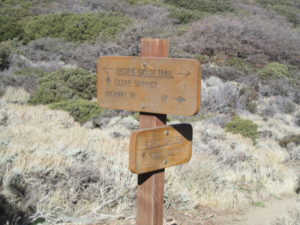
Part of the loop includes a segment of the Pacific Crest Trail on the Desert Divide.
Hikers can enjoy excellent vistas from the Desert Divide on the Pine Mountain Loop.
The 9.7-mile trail consists of the Cactus Springs Trail, a segment of the Pacific Crest Trail, and a connector in the San Bernardino National Forest. Boasting a 2100-foot elevation gain, it passes several shorter peaks along the divide.
March to November marks the best time to hike the loop. As September begins, it’s an excellent way for Coachella Valley hikers to escape the desert heat. Temperatures on the divide will be about 15-20 degrees cooler than on the valley floor.
To reach the trailhead, from Palm Desert, take Calif. Hwy. 74 (the Pines to Palms Highway) south into the mountains. Near Thomas Mountain, just past the Riverside Fire Station #53, turn right/northeast onto Morris Ranch Road. Drive past the Camp Woodcraft. Park off the road at the Cactus Springs trailhead, which is on the right.
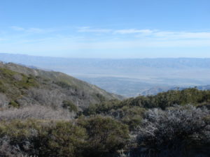
On the Desert Divide, the loop offers an excellent view of Palm Springs.
Take the Cactus Springs Trail northeast. The trail is a wide dirt road that on some maps appears as Pathfinder Road.
At 0.3 miles, the trail crosses then parallels East Canyon Creek. Live oaks offer a shady walk. If winter snows are generous, the creek will flow even in late summer.
You’ll actually enter the national forest at about 0.4 miles. Up to this point, the trail has traversed private land that the U.S. Forest Service has an easement for.
Around 0.6 miles in, the trail splits. The left trail is a connector that continues following the creek to the Pacific Crest Trail. Instead, go right/northeast over the creek.
Along the way, Cone Peak rises to the northwest, topping out at 6815 feet. As with the other peaks along this loop, the trail to the summit is not maintained so requires bushwhacking and rock scrambles. Because of that, the route described here avoids going to any of the summits.
The trail enters a meadow ringed by black oaks at around 0.9 miles. California black oaks usually grows about 30-80 feet high with a trunk diameter of a foot to 4.5 feet. Its acorns are on the larger side for an oak species, with a length of up to 1.2 inches and a width of 0.7 inches. When Euro-American arrived in the area, local Native Americans reported the tree’s acorns to be the best tasting of the oaks.
At 1 mile, the switchback begins up to the Desert Divide. This by far is the steepest stretch of the hike. Your effort will be well-rewarded though.
The trail meets the Pacific Crest Trail at a four-way junction along the Desert Divide at 2.1 miles in. Go right/southeast into the PCT.
With the trail roughly 6800 feet above sea level, here comes that promised reward: an impressive vista of Palm Springs in the desert below with the Indian Canyons area prominent.
As walking east, more of the Coachella Valley becomes visible below with Cathedral City and Palm Desert soon in view. You’ll also be able to make out the Salton Sea’s north end, a blue gem in the tawny desert.
Looking south is Thomas Mountain and Lake Hemet. On clear days, you’ll be able to make the coastal Santa Ana Mountains and the Palomar Mountains.
This stretch of the PCT makes for top-notch vistas because the fauna is mostly chapparal with a few small oak thickets line the path. A few conifers can be seen, but they prefer the higher divide’s elevations. Because of the open terrain, however, high winds can make for an unpleasant walk along the divide during late autumn and early spring.
At 2.5 miles is a spur to Little Desert Peak. Avoid the spur and continue on the PCT.
The trail next veers south. Chaparral and groves of canyon and interior live oaks line the route.
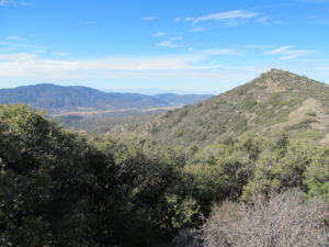
Pyamid Peak, with Thomas Mountain in distance, rises alongside the loop’s PCT segment.
In short order, the trail takes you just below the summit of Pyramid Peak, which tops out at 7015 feet. At 3.2 miles, a spur trail goes up a little of the peak, but it doesn’t head all of the way to the summit.
Pine Mountain rises to the southeast during the trail’s next stretch. It tops out at 7044 feet. You can’t reach its stony top without the aid of ropes and some rock-climbing skills, though.
Just past Pine Mountain is the Devils Rockpile at 6135 feet. Then comes Lion Peak on the left/west, which you’ll switchback down the side of. Lion Peak’s summit is 6854 feet.
At 4.9 miles, the loop splits off from the PCT by going right/southwest. Here the path widens, sputtering from a beat-up jeep trail to a decent dirt logging trail.
The trail descends for the next two miles, crossing Martinez Creek along the way.
About 6.9 miles in, Pipe Creek should become visible. The trail drops into the creek and crosses it.

Pine Mountain Loop topo map
At 7.4 miles, the trail splits. Go right/east. Then at 7.5 miles, make another right turn and ascend out of the Pipe Creek canyon.
During the next mile, the trail crosses a tributary to Pipe Creek as it continues descending the divide.
You’ll reach Morris Ranch Road at 8.7 miles. Go right/north, ascending the mountain via the road Along way is a bridge over Morris Creek. The road then passes Camp Woodcraft, run by the Woodcraft Rangers, started in Los Angeles and a forerunner of the Boys and Girl Scouts programs. During 2022, the camp celebrated its 100th anniversary.
In a mile, the road arrives at the trailhead where you left your vehicle.
Much of the trail lacks shade, so be sure to don sunscreen, sunglasses and a sunhat. There’s no water along the way, so be sure to bring plenty. Though temperatures are far cooler than on the desert floor, the trail still gets plenty hot, so start as early in the day as you can.
Image Sources
- : Rob Bignell
- 04-Pyamid-Peak-with-Thomas-Mountain-in-distance-rises-alongside-the-loops-PCT-segment.: Rob Bignell
- Lilacs bloom: Rob Bignell



![Enrolling Now, Rewarding Careers Ahead [Sponsored]](https://ukenreport.com/wp-content/uploads/2024/04/COD_heroes_1-1385-2-440x264.jpg)


