Elvis Presley was King of Rock and Roll
Day hikers can see Elvis Presley’s Palm Springs home on the Chino Canyon Overlook Trail.
The 0.72-mile trail is not for the faint-hearted. It’s steep and hugs the mountainside.
For the record, “Chino Canyon Overlook Trail” is not the route’s official name; in fact, it’s nameless on most maps. Those that do wrongly identify it as the north trailhead for the North Lykken Trail – but that’s actually in the nearby Las Palmas Estates to the south and runs toward downtown Palm Springs ending at West Ramon Road. So, we’ve christened it the Chino Canyon Overlook, because that’s essentially what the trail offers – a vista of the canyon that boasts both the Palm Springs Tramway and the Elvis Presley Estate.
For the kids out there who think there was no music before Eminem and Kanye, Elvis Presley was the King of Rock and Roll. During the 1950s, he popularized and defined rock music, then in the 1960s turned to movies, which led him to Palm Springs. He’s sold an estimated 1 billion records, 38 of his songs have hit No. 1, and he’s starred in more than 30 feature films. And shame on you for not knowing that.

Chino Overlook Trail topo map
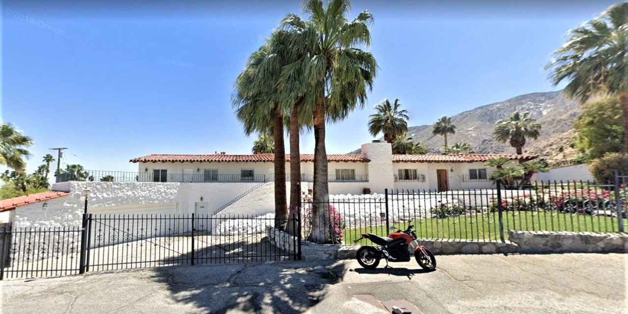
To reach the trailhead, from downtown Palm Springs take Palm Canyon Drive/Calif. Hwy. 111 north. Turn left/west on West Via Escuela into Chino Canyon then left/south on North Via Norte. Next, go right/west onto West Chino Canyon Road. When the road splits, follow it right/north.
After passing North Leonard Road, the Elvis Presley Estate (845 W. Chino Canyon Road) is the second house on the left/south. Once you’ve taken in the view, turn left/southeast onto West Panorama Road then right/west onto West Cielo Drive. In 400 feet, turn left/southwest onto an unmarked street. Park at the end of the cul-de-sac.

The first portion of the Chino Overlook Trail switchbacks up a steep foothill.
The trail heads straight for the foothill, crossing about 0.02 miles of flat desert. It then begins a series of steep switchbacks up. At 0.15 miles from the trailhead, you’ll reach a great vista.
To see the back of the Elvis Presley Estate, use the point where the trail touches the overlook as 12 o’clock. The estate is at about 2 o’clock to the northeast, a roughly U-shaped structure surrounding a swimming pool.
Famous architect Albert Frey designed the home for the Jergens family – which made skincare products – in 1946. McDonald’s mogul Ray Kroc bought it in 1960. Elvis paid $105,000 for it in April 1970. The last time the house was sold – in 2014 – it went for $1.5 million.
Originally 3500-feet square in size, Elvis in 1974 added 1500 square feet. The year before, acoustic tiles were added to the living room for a makeshift studio, and he recorded three songs there. He spent about three months a year living in Palm Springs. When Elvis died in 1977, Frankie Valli bought the home.
The vista also offers a great view of the northern Coachella Valley. Palm Springs spreads out below to the east and south with Thousand Palms and Cathedral City beyond it. Mount San Jacinto looms high above in the west.
Continue heading south on the trail. It briefly switchbacks then hugs the edge of the foothill as descending.

The Elvis Presley Estate can be seen from the trail’s first lookout.
About 0.3 miles in at the end of where the switchback goes east, pause. Here you can spot Elvis’ Honeymoon Hideaway (1350 Ladera Circle). Look for the first long north-south street below the foothill. That’s North Rose Avenue. Locate where the desert meets the housing in a west-east line. Follow that line east across North Rose Avenue. The mansion sits off the first cul-de-sac with a tennis court immediately east of it.
Located in the Vista Las Palmas neighborhood, Elvis and his fiancé Priscilla rented the house for one year beginning in September 1966. They spent their first night as a married couple there on May 1, 1967, hence its nickname.

A closeup of the back of the Elvis Presley Estate.
The trail next descends to the bottom of the ridge, which it reaches at 0.37 miles, then climbs up to the end of another one. It flattens out most of the way then curves south and descends into Tachevah Canyon. Unless you want a skyline view of the Los Palmas Estates, there’s really no reason to take it that far though. Turn around at the bottom of the ridge, as you’ve got to go uphill on the way back and still descend the foothill’s steep northern face – strenuous exercise even if it goes downhill.
While San Jacinto Peak’s shadow will leave much of the trail in shade by late afternoon, the trail otherwise is open to the sun. Be sure to don sunscreen, sunglasses and sunhat. Good hiking boots and a trekking pole to maintain your balance are recommended.
Image Sources
- The first portion of the Chino Overlook Trail: Rob Bignell
- The Estate from the First lookout.: Rob Bignell
- A closeup of the back of the Elvis Presley Estate.: Rob Bignell
- Elvis Presley home: Rob Bignell