You do not need national forests to find breathtaking beauty
With California’s closure of national forests through at least the middle of the month, Coachella Valley hikers will have to find new stomping grounds.
Most local and visiting hikers this time of years still are escaping the valley floor’s parching heat by going to higher and more temperate ground – and that usually means the San Bernardino National Forest, which covers most of the foothills on the valley’s urbanized side. Closure of the national forest also has cut off Mount San Jacinto State Park from hikers.
That leaves Joshua Tree National Park as one of the best local options for valley hikers.

The Fortynine Palms Oasis Trail cuts through largely barren and rocky terrain in Joshua Tree National Park.
Temperatures still will be hot in the high desert, so you’ll want to limit hikes to the morning or early evening. The higher elevation, however – Joshua Tree’s entrances are about 2200 feet above Palm Springs – does mean slightly cooler temperatures. Highs at Joshua Tree this time of year are between 5 to 10 degrees cooler than those in the Coachella Valley.
Joshua Tree offers a variety of environments to explore.
Geographically, the national park is defined by its six mountain ranges with basins in between. Fault lines running through and between these ranges sometimes sport desert oases.
One great hike to an oasis is the Fortynine Palms Oasis Trail. The 2.8-mile round trip trail offers a number of panoramic views and the chance to see desert plants and wildlife. A single track of sand and gravel heads uphill through the often barren and rocky landscape. Stone stairs along the way help your ascend and descend the ridgelines. Sections of the trail are an old Native American path that led from the desert to the oasis spring.
California fan palms rise between boulders that shade a trickling spring and its pool. Songbirds flock there, especially orange and black orioles who feed on the ripe berry-like fruit of the palm tree.
Joshua Tree National Park also sits at the transition line between the Mojave and Colorado (a section of the Sonoran) deserts. It marks the southwestern edge of the Mojave and the western side of the Colorado.
The Mojave Desert is above 3000 feet elevation and makes up the park’s northeast section. It’s dominated by Joshua trees, the park’s namesake, and looks like the desert around Las Vegas.

The West Side Loop explores the Mojave Desert portion of Joshua Tree National Park.
The West Side Loop stands out as a great trail for exploring the park’s Mojave portion. The 4.7-mile West Side Loop is easy to get to and offers a variety of experiences because of its 784-foot change in elevation. You’ll cross a number of washes and ridges, providing an opportunity to see a different flora native to the Mojave.
The loop doubles as an equestrian trail, so you’ll definitely feel like you’re in the Old West. A good topo map and compass are a must for this route.
The Colorado Desert is below 3000 feet and includes the Pinto Basin and the park’s southeast portion. It is similar in appearance, flora and fauna to the Coachella Valley and the Phoenix, Arizona, area, the latter sans the saguaro cactus.
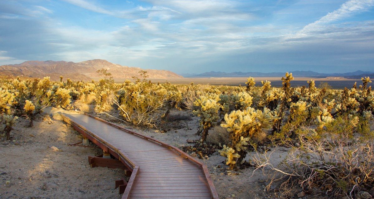
An exotic trail to explore the park’s Colorado portion is the 0.25-mile Cholla Cactus Garden Trail, which loops through a forest of thousands of cholla cactus. An excellent time to visit the garden is about an hour before sunset when the cacti seem to glow in the changing light.
It’s a particularly unique site because creosote bush and burrobush dominate the basin’s expanse of alluvial fans. This particular spot, however, is ideal for teddybear cholla. About 4 inches of water seasonally flows out of Wilson Canyon over a loose mixture of broken rock and soil, which nicely holds the moisture. This spot is for teddybear cholla what the Mediterranean is to humans.
Of course, the main reason most visit Joshua Tree National Park is to see the spectacular granite monoliths. There are plenty of options to choose from, but a sure bet is the Skull Rock Trail, which runs 1.75-miles round trip through the famous Jumbo Rocks, a collection of massive, rounded granite rocks that many park visitors often clamber over.
These monoliths – exposed monzogranite boulders and domes – formed over the past 180 million years as the North American and Pacific tectonic plates slipped past one another. Erosion has removed the softer rock covering the gneiss. Some of the exposed gneiss boulders at the park are as tall as 20-story buildings.
Be forewarned that there is virtually no shade on any of Joshua Tree’s trails, so always don sunscreen, sunglasses and sunhat, as well as bring plenty of drinking water. Hiking boots with good traction and a trekking pole will help you on the ascents and crossings of the sandy washes.
Related articles that include driving directions
West Side Loop (Mojave Desert)
Cholla Cactus Garden Trail (Colorado Desert)
Image Sources
- 02-The-Fortynine-Palms-Oasis-Trail-cuts-through-largely-barren-and-rocky-terrain-in-Joshua-Tree-National-Park.: Rob Bignell
- The West Side Loop: Rob Bignell
- Teddybear-cholla-: Rob Bignell


![Enrolling Now, Rewarding Careers Ahead [Sponsored]](https://ukenreport.com/wp-content/uploads/2024/04/COD_heroes_1-1385-2-440x264.jpg)