
Day hikers can traipse across the metaphorical coals that make the Coachella Valley such a pleasant place to be via the Cathedral City Foothills Trail.
While many trails crisscross the foothills surrounding the valley floor, a moderately challenging hike that’s easy to reach is this 1.5-mile round trip path that leaves from the cove at the end of Cathedral Canyon. There’s no official name for well-worn path, so it has been christened the Foothills Trail here for convenience sake.
To reach the trailhead, from Calif. Hwy. 111 in Cathedral City, turn south onto Cathedral Canyon Drive then left/west onto Terrace Road. At the Vista Drive intersection, park on the street; head north onto the sand-covered, unfinished Vista Drive. When the road curves west and ends at the development’s edge, take the dirt path entering a wash and then the foothills.
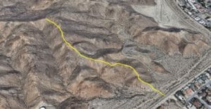
Cathedral City Foothills Trail aerial map
The wash marks the boundary of the San Jacinto-Santa Rosa Mountains National Monument. The public land, administered by a number of federal and state agencies, covers 280,071 acres and stretches from the border of San Diego and Riverside counties southwest of Mecca to Interstate 10 east of Cabazon.
About midway through the wash, which sits at 450 feet elevation, the trail forks. Go left/west. You’ll soon begin climbing a ridgeline. In less than a fifth of a mile, the trail reaches 656 feet elevation.
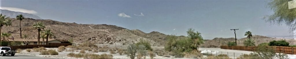
The Cathedral City FoothillsTrail runs on the west side of the cove at the end of Cathedral Canyon.
The ridgeline offers increasingly great views of the Coachella Valley below and the Little San Bernardino Mountains beyond. You also get a good sense of the crumpled landscape that makes up the foothills, which can appear monolithic from the valley floor. If hiking in the morning, you might even feel heat rising off the surface.
If so, you’re sensing the thermals that help ensure the Coachella Valley is a tourist and snowbird destination.
As sun warms the earth, the ground heats the air directly above it. Soon small plumes of warm air – known as thermals –rise then twist and flow with the wind at a rate of up 1-3 yards a second. This displaces the cooler air above that then descends to the ground and in turn is warmed. The sparse, rocky surface of the foothills and mountains surrounding the valley are an ideal surface for creating thermals, because they have a more direct angle to the sun than the valley floor and so heat faster.
The thermal belts across the foothills leads to higher night-time temperatures in the winter and lower daytime temps during the summer. For example, in nearby Palm Desert, the average daily high is 87.1 degrees F while the average daily low is 62.8 F – the usual temperature across the valley at the end of April or mid-October.
Besides the temperate climate, thermals also create a great amount of lift, which birds can take advantage of. On the Foothill Trail, red-tailed hawks often can be seen riding the thermals, usually in wide circles.
Red-tailed hawks prefer the foothill’s open country where they can more easily spot prey. If you see one dive slowly, its legs outstretched, in its attack mode.
The red-tailed hawk can be difficult to identify unless you’re above them or they tip your direction as curving through their air. They are dark brown with light barring on their wing feathers and brilliant red tail feathers. Though adults stretch 18 to 26 inches from head to tail and boast a wingspan of 3.4-4.8 feet, they are extremely light, weighing a mere 2.4 pounds.
In addition to being beautiful, they are vital to population control of rodents, which can make up to 85 percent of their diet. They also enjoy a good snake, lizard and even a jackrabbit now and then.
Another benefit of the thermals is the valley’s agricultural industry. While it can’t be seen amid the housing developments and golf resorts from this trail, in the valley’s southern portion the warm year-round climate allows farmers to grow fruits such as dates, figs and mangoes. Indeed, overall crop production exceeds half a billion dollars a year in the valley.
When the Foothill Trail reaches a T-intersection with another unnamed trail at 1148 feet elevation, you’ve reached the turnback point at about 0.75 miles from the trailhead. Take in the great views, and then retrace your steps back to Terrace Road.
Image Sources
- Cathedral City Foothills Trail: Rob Bignell
- Cathedral City Foothills Trail: Rob Bignell
![Healthy Desert, Healthy You [Sponsored]](https://ukenreport.com/wp-content/uploads/2026/07/2026-v2-Takaahi-Wada-Angelica-Geter-800x568-1-440x264.jpg)