Trail Crosses Fantastic Ridge West of Mount San Jacinto

The Fuller Ridge Trail offers a spectacular view of Mount San Jacinto’s northwest face.
Coachella Valley hikers can enjoy fantastic views of Mount San Jacinto while escaping the summer heat on the Fuller Ridge Trail.
The 10-mile round trip trail in the San Bernardino National Forest crosses a ridge anyone driving from the Coachella Valley into Banning has seen. As heading through the San Gorgonio Pass, it’s the massive ridge emerging westward from Mount San Jacinto.
Starting at roughly 7720 feet above sea level, the Fuller Ridge Trail is best done in July through September, when there’s no snow on the mountains. During the summer, morning temps on the ridge can be in the low 50s with daytime highs in the 80s, some 30-40 degrees cooler than the desert floor.
To reach the trailhead, from the Coachella Valley, take Interstate 10 west through the San Gorgonio Pass. In Banning, go south on Calif. Hwy. 23. Drive about 17 miles then turn right onto Black Mountain Road. The trailhead is in about 8 miles. Along the way, Black Mountain Road becomes “Black Mountain Truck Trail” on maps. At the junction with 4S01C-Fuller Spur C, go right/south. There is limited parked where the spur ends, which also is the trailhead.
Note that Black Mountain Road can be rough the higher you go, so a 4WD vehicle is recommended.
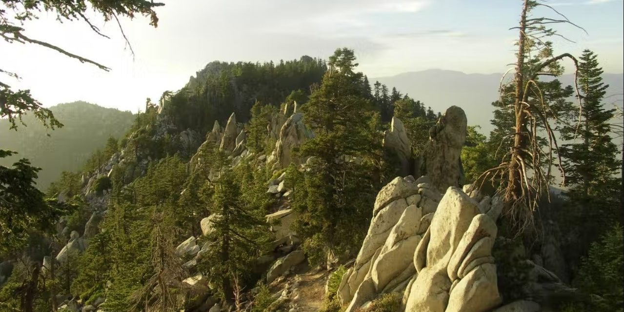
From the lot, the trail heads southeast on a single track, following the timbered ridge above Snow Creek. This also is a segment of the Pacific Crest Trail and for many a quick way to summit San Jacinto Peak.
Pine, cedar and fir line the top of the granite mass, so you’re almost always in the shade. Mount San Jacinto, which tops out at 10,804 feet, looms ahead.
The trail hugs the northeastern side of the ridge for the first 2 miles. At various vista points, you’ll spot Mount San Gorgonio rising in the northwest while the top of the Coachella Valley with Desert Hot Springs and the Little San Bernardino Mountains are to the northeast.
During the trail’s first mile, you’ll pass Castle Rock on the right/south. It tops out at 8592 feet and boasts a number of interesting rock formations.
About 1.25 miles in, the trail enters Mount San Jacinto State Park. Don’t worry, there’s no entry fee booth here.

Great views of the northern Coachella Valley and of the San Jacinto Valley await on the Fuller Ridge Trail.
Get your camera out at around two miles from the trailhead. You’ll be treated to an excellent vista of Mount San Jacinto’s northwestern flank.
The trail next dips, losing about 200 feet in elevation as you head to the ridge’s southwestern side. At 2.5 miles, the trail ascends again, gaining 350 feet over a half mile.
Between 3-4 miles in, along the northside, the ridge’s sides plunge into Snow Creek Gorge. In exchange for the dizzying heights, you’ll have great views of the desert below.
At about 3.3 miles, the trails dip another 200 feet as moving off the ridge onto Mount San Jacinto’s western flank.
Along the way, you’ll first cross an intermittent stream flowing out of Folly Peak, which rises to 10,483 feet then a second intermittent stream that flows out of the saddle between Newton Drury (10,178 feet) and Jean (10,506 feet) peaks.
At 3.7 miles, the trail climbs again, gaining about 400 feet over the next 1.3 miles.

Fuller Ridge Trail topo map
You’ll reach the turnback point, the junction with Deer Springs Trail, at about 5 miles in. You’re at 8960 feet elevation, still a full 184 stories below Mount San Jacinto’s summit, but almost seven Empire State Buildings above Palm Springs.
You can continue on Deer Springs Trail for 2.5 miles to the top of San Jacinto Peak. The PCT also continues south from the junction, next intersecting the Seven Pines Trail (2E13).
Beware of altitude sickness this high up. Since air pressure is lower at higher elevations, you will inhale less oxygen on the ridge. To avoid altitude sickness, go at a slow pace that allows time for acclimatization.
Signs of altitude sickness include shortness of breath, dehydration, headache, nausea and dizziness. If you become confused, clumsy, vomit, and have a dry cough, the condition is serious.
Treating altitude sickness requires descending to a lower elevation where there’s more oxygen. In addition, drink extra water to avoid dehydration, and eat light, high-carbohydrate meals. If the condition is serious, get medical attention immediately.
Given this and the trail’s length, bring plenty of water. There is none along the trail.
Image Sources
- Fuller Ridge Trail: Rob Bignell
- Great views: Rob Bignell
- Castle Rock: Rob Bignell