San Jacinto Peak is the highest point in the San Jacinto Mountains and Riverside County

At more than 8500 feet high, snow sometimes sticks in the cold crevices of Mount San Jacinto Peak until June and are visible from the Desert View Trail.
With the summer heat beginning to rise across the Coachella Valley, one great way to escape it is a hike on Mount San Jacinto.
Towering 10,824 feet into the sky – a full 1.95 miles above Palm Springs – San Jacinto Peak is the highest point in the San Jacinto Mountains and Riverside County, and the sixth highest in the lower 48. It dominates Palm Springs’ skyline and can be seen throughout the valley.
Daytime temperatures are a good 20 to 30 degrees cooler on the mountaintop than on the Coachella Valley floor. That alone almost makes Mount San Jacinto’s fragrant evergreens, shaded trails, and fantastic views a mere afterthought.
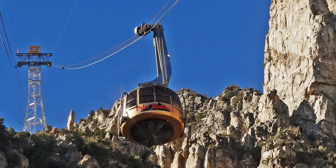
The best way to reach the mountaintop is to cheat a little by taking the Palm Springs Aerial Tram. From Palm Springs, drive Calif. Hwy. 111 north to the tram’s Valley Station, which sits at 2634 feet elevation. The tram climbs 6000 feet and lets you start the hike at 8516 feet in Mount San Jacinto State Park. There is a fee to use the tram, which just reopened for the season.
After taking a few steps off the tram, you’ll probably wonder why you’re breathing a lot harder. There really is less oxygen up there, so take it easy for a bit. Fortunately, the tram’s mountain station is a good spot to acclimate yourself to the higher elevation. The station includes an observation area, restaurant, snack bar and gift shop.
Plenty of hiking trails run across Mount San Jacinto. Indeed, more than 54 miles of them crisscross the 14,000-acre state park. Here are three of them that are easy to reach from the tram’s mountain station.
Though only 1.5-miles round trip, the hike still delivers a vigorous walk thanks to the high altitude. The Desert View is a wide trail through an alpine forest of towering Jeffrey pine with grassy knolls. Five signposts marked as “Notches” appear on the trail to indicate lookouts of the Coachella Valley more than a mile below. Notch 3 arguably offers the best vista, an unimpeded 120-degree view in which the bulk of Palm Springs can be seen.
From the station, go onto the Round Valley Trail and follow the signs. It’s 11.5 miles roundtrip to the peak’s top with a 2400 feet elevation gain. Expect summit temps at the peak to be 40 degrees lower than in the valley. The views from the peak are fantastic. To the northwest is San Gorgonio Peak, the highest summit in Southern California. Little San Bernardo Mountains rises in the northeast. Looking east, you can see Palm Springs and Cathedral City in the valley below. On the clearest of days, the gleaming blue of the Pacific Ocean is visible to the west.

04 Willow Creek flows throughout the year high on Mount San Jacinto and can be enjoyed via the Willow Creek Trail.
A good hike that will be a challenge for new hikers but a moderate workout for longtimers is this 8-mile round trail. From the station, walk into the state Park by heading uphill and west to Round Valley. At 0.3 miles is the Willow Creek Trail; go left/south onto it. Jeffrey pines abound. The plain mariposa lily and lemon lily bloom in June.
Other hikes in the state park are available along Calif. Hwy. 243 that runs between Idyllwild and Banning. Most of them start high in the desert foothills and link to the wooded Desert Divide.
Fascinating Fact: The Cahuilla Indians called San Jacinto Peak I a kitch (or Aya Kaich), which translates to “smooth cliffs,” an appropriate name given that the mountain’s north escarpment at 10,000 feet is the most severe in all of North America. For the Cahuilla, this was the home of Dakush, their founder.
Notes: Dogs are not allowed on state park trails. Cell phone reception will be weak and at times nonexistent on the mountaintop.
Image Sources
- Begin your hike on Mount San Jacinto: Rob Bignell
![Healthy Desert, Healthy You [Sponsored]](https://ukenreport.com/wp-content/uploads/2026/07/2026-v2-Takaahi-Wada-Angelica-Geter-800x568-1-440x264.jpg)